V.T. Frolov, T.I. Frolova. The Origin of the Pacific Ocean
Ссылка на издание на русском языке: В.Т. Фролов, Т.И. Фролова. Происхождение Тихого океана. – 2-е изд., доп. М.: МАКС Пресс,.2011. -52.с.: ил.
УДК 2:551.263.03.(265)
ББК
V.T. Frolov, T.I. Frolova
The Origin of the Pacific Ocean
M.:……..2011…..p. 3 fig.
ISBN………….
In spite of the fact that the Pacific Ocean is considered the most challenging and inhomogeneous, its history and origin are comparatively well documented and may provide the key to understanding the origin of other oceans. In our report, the facts known to the authors are grouped into five blocks: 1. Main characteristics of the relief, tectonics, magmatism, lithogenesis and geological history of the ocean in whole, and more detailed analysis of three or four big areas. 2. Sedimentary formations. 3. Magmatism, magmatic series and formations. 4. continental margins, especially the western margin that is the key to understanding the ocean genesis in general. 5. Main features of the actual (“empiric”) geological history and origin of the ocean. The Pacific Ocean was formed by the combination of multiple factors, forces and mechanisms, both fixistic and moderately mobilistic, while the processes of continental crust oceanization and taphrogenesis had been dominant. The main points are summarized in the conclusion. An analysis of the physical properties of the ocean’s geological formations have provided the proof not only of the young age of the Pacific Ocean (and the other oceans) – not older than 200 million years, but also of the age of the Earth’s entrance into the oceanic period, because the present-day oceans probably did not, exist on the Earth in their present form until the middle of the Mesozoic period. It is also possible to conclude that the ocean formation processes on the Earth have not slowed to the present day.
ISBN……. © Frolov V.T. 2011
INTRODUCTION
In the early 1960s of the XX-th century, the idea of ocean geology and origin, on the whole, and of the Pacific Ocean, in particular, became the hottest geological subject of the day and a core issue polarising geologists into two opposing camps, with some groups inbetween. Furthermore, many geologists consider that the Pacific Ocean greatly differs from the other oceans not only in its huge size (about 40% of the Earth’s surface and about 50% of the oceans – 178.7 million sq. km), asymmetry and complicated structure, but, supposedly, also in the greater age of its history and length of development [62-64,109]. Its ‘primordiality’, and ‘primeval earth asymmetry’ was supposed to have been laid in the early stages of the planetary accretion and preserved to the present day.
Nevertheless, in its present-day physicality the Pacific Ocean is neogenic and young, and in age does not differ significantly from other, undoubtedly, Meso-Cenozoic oceans. This contemporaneous view of the oceans’ development raised the question of their origin on a global scale, but, at the same time, the answers could be arrived at independently for any of them; and it seems to be logical to start from the youngest Cenozoic Arctic Ocean. However for science the conceptual awareness of ocean geology would be easier, if it were based on the geology of the Great Ocean, it being the most developed and clearly structured one, or according to Yu. M. Pushcharovsky [62-64], Superocean.
During the last 200 million years, the formation and development of the modern oceans has been the most central event of the Earth’s geological history; and that fact seems to be acknowledged by all scientists [33]. But there is disagreement about how the present situation came about as well as the future development of the oceans: some geologists believe that advance of sea, partly in Eocene or even in the early Cretaceous period (Koryakia) changed to “continentalization”, i.e. ocean closure; other geologists don’t see any changes in the trend. This problem has not only scientific also practical importance, though not immediate for countries such as Japan, China, Russian Far East and some others [91, 92]. The principal geological trend of continents and oceans interaction must be established to solve this problem, particularly to answer a question - whether the trend common for the whole Earth and progressive for oceans (and regressive for continents) was interrupted anywhere, whether the oceanization of continents was terminated at whatever place, and whether their closure, continentalization began? Present day geology is already able to solve such problems with a relatively high degree of certainty. Accumulated experience and different facts make it possible to reconstruct the virtual, empirical (with some assumptions unavoidable in historical studies [94]) history of oceans and, first of all, – the Pacific. We have classified the facts into five groups: 1) General characteristics of the ocean floor fracture zones and rises outside of continental margins; 2) Sedimentary formations of that, main, part of the ocean; 3) Magmatism, magmatic geological series and formations; 4) Transition zones, or continental margins; and 5) Geological history and origin of the ocean.
CHAPTER 1. STRUCTURE OF THE OCEAN BASINS AND RISES FLOOR BEYOND THE OCEAN MARGINS
The Pacific Ocean has a sharply nonuniform, asymmetric, and inlaid geological structure [47], which definitely excludes the possibility of its development from a single center or a single zone. The western and the eastern part, Western Pacific (WP) and Eastern Pacific (EP), on their relief, tectonics, and geological history are actually two different oceans divided by the geological interface of Krasny [30-33], with which the regional flexure is in the close agreement. To the east of the interface, the Moho surface [40] slopes downward for some kilometers. In the north, the interface passes through the Emperor Ridge (fig.1), the fracture with the same name, and Hess Rise, or more exactly – to the east of it. Farther, it passes along the Hawaiian Ridge almost not changing the eastward direction, only sharply moving back (along the fault?) to the west, then along the Hawaiian Ridge and once more offsets to the west in a zigzag manner – along the Lain Ridge and Tuamoty Rise. Possibly before that rise the boundary deviates to the east more steeply, and from the east follows the Marquesas Rise that is close to Tuamoty on its geology. To the south, the interface is unclear. A latitudinal boundary gets sharper and, according to Yu. M. Puscharovsky [63], the South Pacific (SP), which is bordering in the north on WP and EP, may be distinguished too. Latitudinal boundary of this third part of the ocean goes along 26о S, following the south part of the Tabuai Islands in the west, and almost directly approaching the Tonga Deep-Sea Trench (DST) at the border of the Louisville Ridge (from SE). Further to the SE [47] is the regional fault Eltanin skewed to the South Pacific Rise (SPR). To the east of the Tuamoty, the SP boundary goes through a big fault – the Easter Island Fracture and the Sala y Gómez Ridge, approaching the Chile DST southwardly of the Nasca Ridge end point.
Western Pacific or the Western-Pacific Depression is unique, complex and, for the most part, is clear in respect of its genesis. With regard to the relief, tectonics and geological history, it is close to the Western Active Continental Margin (WACM [84]), distinguishing from it by vast abyssal plains – more extensive oceanization of the sea floor, what proves its older age. This fact has been confirmed by the dating of floor rocks, basalts and lower horizons of the sedimentary cover. The oldest rocks (Jurassic, or possibly, Pre-Jurassic) were found in 2000х 2000 km quadrangle to the east of Mariana DST, between 23 and 13оN, and 150 - 170оE [34]. The oldest paleobasalts (T3-J1) were found [14, 15] on Tahiti island. The age of basalts of the Pythaget Basin (near the Mariana Islands) is about 180 million tears.
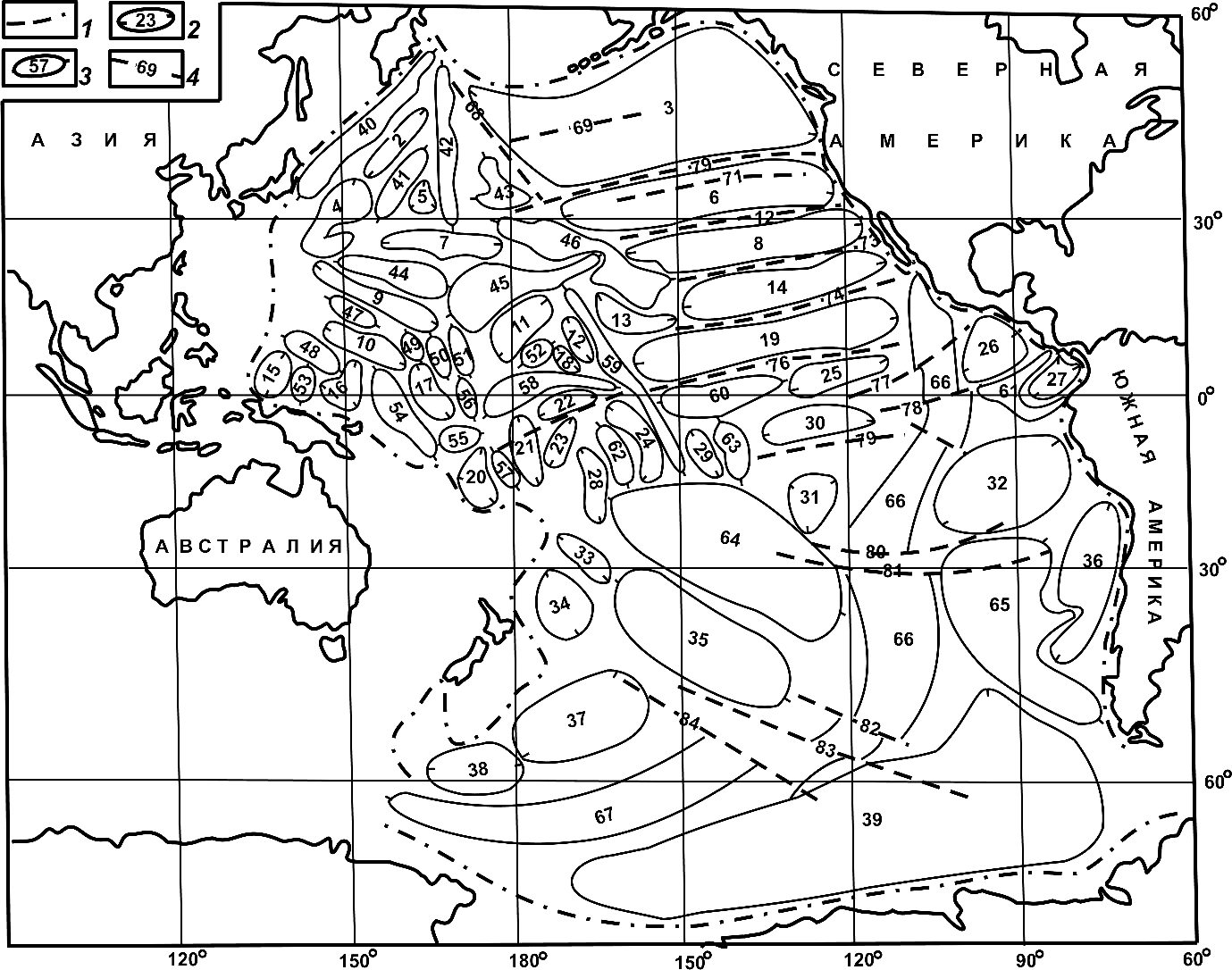
Fig.1 The Map of the Major Structural Elements of the Pacific Ocean Floor.
1 – Boundary; 2 – Fracture zones (2-39); 3 – Rises and uplifts (40-67); 4 – Main faults, (68‑84). Fracture zones: 2 – Papanin, 3 – Chinook, 4 – Isakov, 5 – Milwaukee, 6 – Mendocino-Murray, 7 – Bailey, 8 – Murray-Molokai, 9 – Minamitory, 10 – Saipan, 11 – Magellan, 12 – North Palmira, 13 – South Hawaiian, 14 – Molokai-Clarion, 15 – West Caroline, 16 – East Caroline, 17 – North-Melanesian, 18 – Campbell, 19 – Clarion-Clipperton, 20 – South Melanesian, 21 – Gardner, 22 – Nova, 23 – North Tokelau, 24 – Penrhyn, 25 – Clipperton-Galapagos, 26 – Guatemala, 27 – Panamanian, 28 – Samoan, 29 – Polynesian, 30 – Galapagos-Marquesas, 31 – Tiki, 32 – Peruvian, 33 – Osbourn, 34 – Louisville, 35 – Christensen, 36 – Chilean, 37 – Udintsev, 38 – Simpson, 39 – Bellingshausen. Rises and uplifts: 40 – Zenkevich swell (Hokkaido rise), 41 – Shatsky, 42 – Nort-West Ridge (Emperor Seamounts), 43 – Hess, 44 – Marcus-Wake, 45 – Wake-Hecker, 46 – Hawaiian Seamount chain, 47 – Magellan Seamounts, 48 – Caroline, 49 – Eniwetok, 50 – Ralick, 51 – Radack, 52 – Magellan, 53 – Eauripik , 54 – Kapingamarangi, 55 – Nauru, 56 – Gilbert, 57– Tuvalu, 58 – Howland, 59 – Lain, 60 – Gagarin, 61 – Central American, 62 – Manihik, 63 – Marquesas, 64 – Polynesian swell, 65– Chile rise, 66 – East Pacific (EPR), 67 – South Pacific (SPR). Main fractures (zones of fractures): 68 – Emperor, 69 – Chinook, 70 – 70 – Mendocino, 71 – Pioneer, 72 – Murray, 73 – Molokai, 74 – Clarion, 75 – Nova-Canton, 76 – Clipperton, 77 – Siqueiros, 78 – Galapagos, 79 – Marquesas, 80 – Kunros , 81 – Easter, 82 – Menarda , 83 – Eltanin, 84 – Udintsev.
The core of the vast Mid-Pacific Mountain Range (mid-ocean ridge) is build up by the Jurassic and possibly older rocks; rim rocks are ankaramites with picrites and trachybasalts (150 million years, J3) and early Cretaceous volcanites (117-133 million years). After cessation of volcanic eruptions, subalcalic basalts and trachytes (30 million years, Oligocene) overlapped these mountains. The long history (150-200 million years, at least) of the Mid-Pacific volcanism and many other seamounts and rises excludes any noticeable drift. To the south, on the equator and more southwardly in the Melanesian Province on the Ontong-Java Plateau and Manihiki Rise, having thick crusts (40 and 23 km, correspondingly), tholeiites (112-120 million years, К1) were uncovered under limestones by the borehole; they are similar to MORB and, at the same time, of a different type (low-titanium and with increased content of potassium and other elements of the same group) – close to some WACM basalts. In the Nauru Trench and on the Lain Ridge (right on the boundary with EP), primary volcanic rocks have Cretaceous age (Nauru is 110-130 million years, hole 462, and Lain is 126 million years). The crust in the Lain Ridge is heavily crushed, as well as in many other WP sectors; volcanism (K2) is approaching to the Hawaiian, and in the Paleocene it becomes of alkaline type not specific for the oceans (Chapt. 3). Cretaceous volcanites occur widely, but the Cenozoic to recent ones – only on the islands; it indicates that WP depths were cooled after intense heating-up in the Cretaceous period. The diversity of WP basalts is a criterion (secondary) of the central ocean’s non-uniformity [8,9,13-17,31,32,40,45,65,74,78,82,115].
The fact that the western and the eastern part of WP don’t differ essentially in their age means that WP was developing simultaneously in different parts, mainly as a single but complicated megastructure, except for its northern part (see below, and Chapt. 5). Magnetic anomaly strip mapping of the basalt bed’s gradual “rejuvenation” from the early Jura to Palaeocene (in WP) and to the Miocene-Anthropogene (WP and SP) beginning from the center near the Mariana Islands in all directions, besides the western one, only gives us a vague approximation – but, nevertheless, it excludes the monospreading (from one “mid-ridge”) in Pacific Ocean history. More detailed explorations have showed the inconsistency of the concentric scheme, the picture becomes mosaic, and the sea floor looks like a set of keys.The block structure of the sea floor [32] is also evident by the irregular distribution of the continental crust (CC) residual mountains, sudden changes in ages and thicknesses of the oceanic crust (OC) on the boundaries with adjacent blocks, and by the local rifts with different orientation, which we have succeeded in reconstructing.
The remnants of the early continental crust have been found or likely to be found [8,9,13-17] in the basements of many seamounts - Shatsky, Obruchev, Hess, Mid-Pacific, Manihiki, Magellan, Eauripik, Ogasawara (some of them [46] form a part of the Darvin Rise), Marquesas and other islands and guyots, practically everywhere in WP. They didn’t drift far away and, thus, are indicative of vertical movements only, mainly subsidence of the basin floors. And in the effusive rocks of young volcanic ridges, xenoliths of the ancient deep-seated rocks are found too (Hawaiian garnet pyroxenites), as well as isotopic tags [12,126] of the under-lithospheric mantle similar to the mantle beneath the continents ([116], see Chapters 3 and 5). This fact led S.M. Tabunov et al. [40, 78] to regard the entire Pacific Ocean as an ancient submerged platform divided by subglobal and local riftogenic belts-rises.
Thickness of the crust varies beginning from some few kilometers to 20-25 km and even to 40 km (Otong-Java), and often stepwise. The average thickness of the crust in WP (8.2 km) is greater than in EP (5.7 km). The thinnest crust is in the deep-sea basins. The average thickness of the second (basalt, 2.7 km) and third (basite-hyperbasite, 5.5 km) crustal layer in WP is also greater than in EP. In some places the third layer is abnormally thick; and the Moho surface of those “mountain roots” (volcanic ridges and rises) has lowered (by 6-8 km). Average depth (³4.5 km) of the ocean in WP is greater than in EP, as well. The structure of a thin (hundreds of meters) sedimentary cover (J-Q4, first OC layer) is clear; the cover includes only oceanic formations (see Chapt. 2). At underwater uplifts (Shatsky, Obruchev and et al.) terrigene and planktonogene sediments [45] are abnormally thick (1-2 km), and are likely flysch. By the end of Oligozen the terrigene material was brought from Kamchatka, Beringia, the Sea of Okhotsk, N. America as well from internal uplifts, which could be parts of an old continent with a severe topography with volcanic and other mobile belts (VB and MB). This land that in the Late Tertiary period became the northern part of the Pacific Ocean, in Eocene and Oligocene supplied arkosic and greywacke rocks to the Komandorski Islands flysch depression [93,103]. In his oral report Yu.G. Volokhin mentioned of a more localized thickening of the first layer in the zones of local upwellings at the root of high mountains, because of the increased bioproductivity.
The highest (to 5-7 km) submeridional north-west, sometimes latitudinal ridges, island and underwater volcano-accumulative isometric uplifts and oceanized residual mountain borderlands are separated by wide subisometric trenches and where closing dikes are – by their chains similar to the belt of the Asian and Australian marginal seas (Chapt.4). The present megarelief of WP is mainly inherited from the Cretaceous period and, furthermore, the places of location, depressions, ridges, and rises remained intact [16, 47, 82]; most often a negative or positive sign (of subsidence) remained unchanged too, i.e. practically without inversions and essential horizontal movements. In the Cenozoic era new superimposed volcano-accumulative ridges appeared: the Hawaii and others. Mostly, there are differently orientated straight-line ridges, rises, and fractures insensible to the plate drifting. The local slightly-separated and differently-directed short rifts [9, 33] (island chains are connected with some of them), as well as the differently directed fissures (sharply different from the transform ones in WP and SP) exclude plate or block migration too. The magnetic field, the same as the crustal structure, reveals mosaicity. Inversion linear magnetic anomalies [47] outline [78] the ancient, local Cretaceous rifts. A weak heat flow and seismicity (earthquakes are shallow-focus and rare) are indicative of the passive modern geodynamics.
So, despite a variable and severe topography and complex geology, in terms of geodynamics and geological history WP is integral, and as we will see below, differs from the younger EP and SP which on the Earth’s present face undoubtedly look simpler than WP: that’s why they are called Neopacific in contrast to Paleopacific (WP). Mosaicity of the sea floor and immobility of its main elements exclude monospreading and significant horizontal movements; and these features clearly indicate the main pattern of WP formation – taphrogenesis, ie. the sinking of individual or groups of blocks on the sea floor, as shown [5,6,23,56,66,82,91,97,117 et al.] in the Asian CM. Accordingly WP, which is geologically very similar to the Asian CM [92,100,111,120, Chapt.4] may be regarded: 1) as the more oceanized, ancient, and still mainly Mesozoic Asian CM, if the Mesozoic ocean was positioned where the present Eastern Pacific is now, or 2) as the main central part of the Cretaceous Pacific Ocean that had practically terminated its evolution, possibly due to the shifting of the warmed-up deep zone in the Cenozoic era to the east, to the present EP and likewise, to the west, to the present WACM zone, which in the early Cenozoic was still a part of the Asian and Australian continents, and to the north and south to the SP zone, as well.
Eastern Pacific has a simpler construction than its Western counterpart, and is younger (mainly Cenozoic) and less comprehensible in terms of its genesis and "pre-history". Its fabric axis is the broadest (in some places to 3000 km) East Pacific Rise (EPR) – the “spreading” or mid-ocean ridge (MOR) is arranged, nevertheless, asymmetrically, closer to American continents which it approaches to, by moving gradually to the north, coming closer to the continental margin at a wide angle alongshore Mexico. At the same time, it is sinking. The ridge gets narrower, loses a "spreading force" and fades out in the Gulf of California and the shear zone of St. Andreas. To refute this fact, the Ridge and Valley Province situated eastwardly, on the USA territory, is sometimes mentioned as an example of spreading for that latitude (Chapt.4) too. Nevertheless, there are typical continental formations and graben valleys filled with continental deposits. It is noteworthy to mention that the province is superimposed (with a slight offset to the east) on the preceding one, congruent Jurassic-Cretaceous system of horsts and grabens. The grabens and trough valleys are built by Jurassic-Lower Cretaceous formations, not oceanic but continental: greywacke and siliceous flysch (Franciscan formation of the Coast Ranges) and eastward – by coarse schlier passing into molasse – the Great Valley series. Over the course of 200 million years, the western part of the N. American continent, not less than 1500 km wide, including the eastern part of EP (see 4) too, has lived in the mode of scattered tension stress and has been fixed geographically; neither now, nor at any time since, has it been connected to EPR.
Given the zero shift in the gulf of California even along the San Andreas fault , S. American latitude spreading even for hundreds of km is hard to explain, but for thousands of kilometers is practically impossible. And how should we subsequently view the stripes of magnetic anomalies which are drawn in the north-east part of the ocean as distinctly as they are along EPR latitudes? Could they then be the result of the same simplification? Sometimes, less extended ridges parallel to the axial rifts are outlined from the EPR west and east [40, 78], and some of them are approximately of the same age. This fact excludes a mono-spreading origin not only of the entire Pacific Ocean, but also EP.
The EP bed, in contrast to the WP bed, is more flat, only hilly, slightly raised and barely covered with sedimentary rocks (to 0.3 km) and submarine weathered red clays. It is dissected by more than thirty major cracks (5-6 thou. km in length) and big lateral transverse to EPR fractures.They are older than EPR, yet they still dissect and variegate it for tens and hundreds of km . There are hundreds of smaller fractures, cutting through all the layers of the oceanic crust with an average thickness of 5.7 km and overturning and mixing the cross sections.The ocean plates of EP appear to be non-monolithic and, in general, they are not capable of moving and causing compression during "clustering". Some of the fractures are faults, along others - vertical movements are visible, third fractures are only slightly-separated.
The average depth of the EP bed is 4.3 km, i.e. close to critical for carbonates.The average thickness of the second (1.2 km) and third (4.2 km) layer of the oceanic crust is more uniform over the area than in WP. These layers have minimal thicknesses in the EPR axial zone (in some places they are not shown up), which one is distinguished among others by the minimal velocities of seismic waves too. Velocity jumps in the third layer where the sea floor is described as having a block structure. The high-speed layer of the crust is found [9] in the basements of some, usually transverse to EPR, rift ridges near the continents; in the depressions it is absent. The Magnetic field of EP, particularly in EPR and in some places in depressions, has more efficient orientation than in WP [46, 47]. However, it has a little connection with the gapping in the EPR axial rift zone - having mainly tectonic, orogenic form and coincident with the volcanic accumulation. The rift valley is narrow (0-2 km) - with a strong hydrothermal volcanism. Occurrence of the areas with differently directed magnetic series [35] allows for reconstruction of ancient, possibly, Cretaceous local rifts. EP rocks have Cenozoic age, mainly not older than Paleogene. Unlike WP, a heat flow in EP is strong, earthquakes are frequent. Since the EPR rise has started in Miocene [2, 3, 33] the, main portion of the WP basalts are not of EPR origin (Chapt.3).
The main mysteries of EP: 1) the reason for the geological and morphological differences between WP and WACM, and 2) composition, structure, age and type of the basement under the thin crust of EP both in depressions and EPR. Drag samples of escarpments give only poor data about Clarion, Clipperton and other fracture zones. There are mainly high-temperature basic metamorphic rocks and occasional gneisses which point to the continental-and-crust basement rather than to the metamorphosed ancient oceanic crust (Chapt.3 and 5).
South Pacific (SP) is studied less than EP and WP, but the available data confirm the conclusions made for EP. In age, structure and degree of oceanization SP is close to EP, although its marginal zones, both western and eastern, have some patterns of WP too. The clear distinction of SP from EP and WP is its limitation by the extended passive continental margin in the south. A sub-symmetry axis of SP – South Pacific Rise (SPR) – is a sublatitudinal south-western extension of EPR. There are a lot of transform faults with elements of gapping and vertical offsets, but almost all of them are semitransversal, mainly elongated from NW to SE; their amplitudes may be up to hundreds of km, but the length of the Eltanin Fracture zone is even more, up to 1100 km. metamorphic rocks of the Pacific Ocean basement - microfold crystalline sсhists, olivine-pyroxene granulites and serpentinized peridotites have been found in these regions [25, 26].
Along SP margins there are big masses of basement, including residual mountains of continental crust, in the west comparable in size to New Zealand: the Campbell Plateau and Chatham [9, 11]; in the east - the reconstructed [14] Arequipa massif which supplied in the Paleozoic and Mesozoic eras fragmentary material to the Andean geosyncline.
The questions regarding SP are the same as on EP: basement origin and the way of its formation. Mono-spreading mechanism (in SPR) seems to be not applicable: there is neither a heaven-sent opportunity of subduction in the south, nor the freedom for the Antarctica migration. The situation with the displacement of "SW plate" to the south is not better. What are the magnetic anomaly stripes in this region showing us? And likewise, there is no other way for SP formation besides taphrogenesis and Earth expansion [49].More on the issue of the genesis - after the basic material presentation: in sections about sedimentary formations (Chapt.2), magmatism (Chapt.3), and geological history (Chapt.5).
CHAPTER 2. SEDIMENTARY GEOLOGICAL FORMATIONS
(F) geological formations – types of the regional parageneses of the genetic types of sedimentary rocks (SGT, [85,89]) or of landscape facies, and for magmatic formations – the parageneses of rocks , are the most important and reliable indicators of the oceans and "non-oceans"; they may be used as criteria for identification of past oceans. Actually, there are only a few oceanic sedimentary formations which lie beyond the continental or ocean margins in oceanic depressions or trenches, and on the separations between those ridges and rises. They belong to sedimentogene biogenic (BF) and mechanogenic (MF) families, and one or two chemo-alluvial (ChAF) formations. The hydrothermal rift structures and the extremely heterogeneous inspissated accumulations can lift their level up to the formations. Subaerial SGT, facies and formations, which mainly had already been "continental", are formed on the islands.
Biogenic Formations (BF) are relatively more diversified, and their representative masses are stratones, which are 60 % or more thicker than the sedimentary cover [4, 34-36]. On bioenvironmental criteria, BFs are subdivided into planktonogene and bentogene subfamilies, and further, the first are additionally subdivided into calciferous and siliceous groups in order of genus. Silicious or siliceous formations are only planktonogene. Calciferous planktonogene formations (CPF) on their rock components are practically homotypic: they are formed by the rocks and sediments of the writing chalk type, and they are often called chalky (Cretaceous). In their composition nanoplankton distinctly dominates, there are almost entirely exoskeleton residuals of the yellow-green algae coccolithophora – coccolithes; and to this extent they are identical to the writing chalk on the land. The similarity applies as well to the second component, foraminifer shells. In the earliest days of lithology and long before the arrival of the science of categorization of rock formations, this purely lithological similarity (rocks seen as identical) led to the mistake that has become the basic misconception, the basis of which students learn to distinguish between geological bodies of different hierarchical levels, and exclude their homogeneity. In his early years A.D. Arkhangelsky, using the results of a four-year round-the-world expedition on the "Challenger", based on the similarity between the writing chalk of the Volga region and the ocean "globigerine silt" mistakenly included the bathyal depths and its oceanic environments as belonging to the Russian tectonic plate. In the 50s of XX-th century, G.I. Bushinski proved that the depth of the Cretaceous sea on the Russian Plate had not exceeded 200 m, and for the ascribing the platform and ocean chalks to one and the same formation it was not enough to have only a lithological similarity: with regard to the way of formation, upon their SGT and geological environment they differ markedly which fact is clearly supported by other lithological, paleontological and geological criteria. Cretaceous (chalky) formations of platforms, geosynclines, and shelf seas differ from the oceanic ones by the presence of benthonic calcareous and silicious fossils, terrigenous and shallow-water sea authigene and edaphogenetic components, a larger number and greater thicknesses of subsea-alluvial calciferous and phosphate shells – a sign of lengthy interruptions in their sedimentation. They differ greatly in the form and size of areas of their development, thicknesses, facial structures and formation parageneses. From the geological point of view, it is impossible to mix them up and complex genetic analysis is required to establish their true genesis [85, 89].
Cretaceous Oceanic Formation (COF) is the most widespread in the Pacific Ocean and one of the most typical and diagnostic for the oceans; by the method of formation it is a bi-genetic, as on the continents – sedimentary and sedentary, but in both cases the origin is biogenic. The formation has a bioplankton genesis with respect to its main component and the way of sedimentation, and is practically totally syn-sedimentary and bioturbated. Besides complete bioeluviation, shells (calcretes) are formed in it from time to time, i.e. additionally a chemoalluvial process develops – a sign of interruptions in the sedimentation. The small thicknesses of regional stratones (tens of m) associated with the formation are indicative of a low speed of sedimentation (as a rule, millimeters per 1000 years,which increases locally at upwellings ).
For the continental basins, the plain-and-depression deposits and subfluvial-mountainous nanoplankton deposits should be regarded as different COF. COF should be distinguished by bathyal and climatic zonality, as well. They are developing, in general, above the critical depth of compensation (CDC), but lower than the depth of stormy waves (above the stormy line a sedimentation process is prevalent and a new formation is created). The foraminifers are used for the identification of low-latitude, warm-water (rotaliids prevail) and mid-latitude moderate cold-water (globigerinoides prevail) COF. In the arid zones, beneath the gigantic circulating (to thousands of km) ocean anticyclonic currents (mainly in the south arid belt in the ocean “deserts”) bioproductivity and terrigene discharge is very low. This regional geological situation is presented by a special COF, the purest one (CaCO3 to 99%), heavily inspissated and having small (meters) thicknesses. The presence of glauconite and absolute bioturbidity are important indicators of the formation (oxidizing environment in the water and in the silt, what means the absence, and only the traces of reduction zone [53, 85, 89]). COF, thereby, is biogenic two or even three times: primarily – physiologically (by formation of skeleton), repeatedly – by biofiltration (formation of coprolites, containing coccoliths, which escape the dissolution by sinking to the bottom more quickly and "tertiarily" – by bioturbation (cyn-sedimentation eating of the sediments by worms and other deposit feeders).
COF may be used for reconstruction of bathypelagic and other conditions mentioned above, the isolation from terrigene siliceous matter during tens of millions of years (1-st paradox), but with the needed to infauna aerated bottom water (2-d paradox) giving the idea of the ocean dimensions. Such formations could be found neither in the modern mediterranean and marginal seas, nor on the platforms and in the geosynclinal seas of the past. Basin bottoms were "purged" by the currents bringing oxygen from the high latitudes; it means that up and across,in area and in depth, the basin was global and oceanic . COF paragenesis with red clays and ocean silicious formations are also indicative of the existence of oceans.
Atoll-type Algal-Coral Reef Oceanic Formation (AARF) may be distinguished by the maximum total thickness (to 3 km) of their stratones, mainly Cenozoic, sometimes with polygenic underwater (sometimes with subaerial) weathering crusts, inclusive calcariferous, phosphatic, mangano-ferro-oxide shells and green earths. The skeleton of reef-atolls consists of algal-coral bioherms to hundreds of meters in height. The"filler" portion is colluvium of all five types: turbidites, planktonogene and benthogenic bioliths, and lagoonal deposits- i.e. tributary. In tropical zones, atolls are arranged in rectilinear or arched chains (to 5 thou. km); they spread out at the base of the atoll to hundreds of km. Colluvial-turbidite and planktonogene sediments of the deep-water straits between atolls are calcareous, too, and belong to the atoll F. Atoll formation helps to reconstruct the geodynamic mode of the floor subsidence, which is often of a quick-downfall type, and which was not always compensated by the various corals’ rapid growth, in which case the atolls become guyots, and other, polygenotype benthogenic-planktonogene, inspissated, sedimentogene subsea-sedentary F accumulate on them these being associated with shallow depth, , active water dynamic and virtually complete,( e.g. as in AARF,) isolation from terrestrial material,. Absence or infrequent occurrence of the New Guinean type shore reefs [85, 89], which are typical for WACM, is a sign of floor subsidence over the period of the entire history of the ocean. Atolls may develop in the adjacent seas; nevertheless, they don't reach oceanic dimensions here, particularly in thickness. Therefore, AARF may be used as a diagnostic property of the oceans and a criterion for their reconstruction.
Siliceous Oceanic Formations (SOF) in the Pacific Ocean, in spite of the abundance and significance of its planktonogene silica accumulations, are inferior to those in other oceans in terms of both in volume and variety. The thicknesses of the regiostratones do not exceed some tens of meters (with the exception of local upwellings at mountain bases), the areas are of a belt-type and in size less than calciferous formations; bio-opal concentrations in the sediments rarely exceed 50% [34-36]. Clay or calciferous formations are substantially more common. But, however, the inferior siliceous component remains the most important indicator of the formation. It usually indicates abyssal deeps (≥CDC), low sedimentation rate (≤1 mm /1000 years) and, in one type of SOF – high latitudes (diatomaceous F, the depths may be less than CDC, too), and in the other type – equatorial belt (radiolarian-diatomaceous F) the required depth exceeds that of CDC. SOF,and as such, they are artificial, only displaying the apparent role of a direct climactic controller. Actually this control is limited in its influence – passive for the silicious plankton, and mediated by the more forceful direct temperature control of the competitive calcareous sediments prevailing in the mid-and-low latitudes. But the siliceous sediments are successful inplaces where calcareous mineralization is excluded (due to the colder waters of the high latitudes), or where it has been brought to nought (lower than CDC) due to dissolving of calcareous substances (equatorial belt). Here, too, SOF becomes an eluvial (sedentary) formation of the Terra-Rossa type, the intermediate phase to the eluvial formation of red clays (see below).
From the two cold belts potentially admissible for SOF sedimentation, only the belt surrounding Antarctica is productive at the present time, where due to the absence of river discharge any other, silicate diluter, has been sufficiently depleted. In the north, in the Aleutian Belt, the terrigenous diluter displaces silica reducing them to background sedimentations such that SOF is not really formed at all. In the adjacent seas of the Sea-of-Okhotsk-type, even taking into account the gravity traps near the shore, accumulation of diatomites was interrupted by turbidites, and they formed only an apical element of the graywacke flysch cyclites (Paleogene and Miocene of the Aleutian and Kuril Island Chains). and the Biosiliceous Jurassic formations of the Sikhote Alin likewise differ from SOF (Yu.G. Volokhin),.
SOF is used as a benchmark of ocean depths across the vast areas, latitudinal zonality and distances between the continents and (of bioturbidity) water aerobicness at the bottom, and nothing on land, even including the Thetis and Iapetus "oceans", can be found to rival it. – these distinctions in scale are the same when we consider the calciferous sediments F (see above).
Mechanogenic Oceanic Formations (MOF) are represented by two megalithotypes: silica-clay and calciferous. If we acknowledge the level of. Their formation, then the Silica, Clay Formations at depression bottoms are mainly of "transit type" common for the continental margins and adjacent oceanic depressions. More often it may be distal flysch (thickness to 1-1.5 km ), which proximal facies, more precisely – facies of the deep-water cones with a thicknesses in the Pacific Ocean up to 2-3 km – are within the limits of CM, but only passive ones. In the Pacific Ocean they practically absent (during last 20-25 million years Antarctic Continent has been producing mainly iceberg material). Only the Canada and south-western Alaska shores, being the "passive" CM, allow for the terrigenous material to settle out on the ocean floor, though major volumes are accumulating within the CM. Possibly, as far back as in the Neogene, when the intercepting Kamchatka and Aleutian DST had not yet existed, the same distal fractions were accumulated in the northwest corner of the Ocean. On the Obruchev, Shatsky, and Hess Rises (Chapt.1) the thickness of the same type terrigene-planktonic deposits (K2-Q) reaches 1-2 km [8,9,14,45], and local material (exported from the North Pacific) must have taken part in it. MOF have potential for oil and gas discovery, as well as for phosphorites (E.L. Shkolnik et. al.)
Other, nepheloid type of clay F is not directly connected with the deep-sea cones: there are nepheloid-like hemipelagic deposits and bathyal "blue muds" (to 100-200 m) of some perioceanic sectors. They are moderately calcareous, with dissipated organic material and reduction layer. These clay formations are less specific for the oceans, but in paragenesis with other F they become diagnostic. On the continents and in the CM, often with diatomic formations, they are oil-bearing (Sakhalin, Alaska).
Calciferous Mechanogenic F may segregate from the atoll F, mainly as colluvial and turbidite one, but only if its nucleating center – piedmont facies of the atoll formation – has reached the geological scale, i.e. if it could be a regional stratigraphic unit. Thickness of accumulations containing planktonogene deposits and underwater shells is to some hundreds of meters.
Eluvial Formations (EF) – this group contains several types: formations of red deep-water clays, of possible underwater-hydrothermal and lateritic subaerial.
Halmyrolytic Formation of Red Clays (RC) – is most typical for oceans and the most useful diagnostically. Red clays cover depression bottoms mainly lower than CDC, they occupy about 35.11% [34, 36] of the Pacific Ocean area what is more than the Eurasian territory. In the cross section of sedimentary cover – RCs are the upper, and their build-up will continue for a long time. The bottom layer of clays is of different age in different parts (from Oligocene, may be from Eocene and Paleocene to Pliocene), thus from the stratigraphical point of view - this is a series of thin regional stratigraphic units that include diatomite and chalky facies. Maximum clay thickness is of 15-20 m, and the time period of their accumulation is about 20-30 million years. The average speed of accumulation is less than 1 mm/1000 years (0.1, maximum 1 m/1 million years). The absolutet minimum speed of the clays build-up is also confirmed by: finds of the teeth of tertiary sharks and whale otoliths (ear crystals) on the clay surface; condensation of cosmic spherules (up to 15-30 in 1 liter of clay, whereas in 1litre of calcareous ooze – there are only 1-2). The very complicated structure of Fe-Mn–nodules suggests that the Fe-Mn–nodules were dwelling in the upper active layer a long period of time (millions of years). Many of the Fe-Mn-nodule formations have a history of tens of millions of years, and this fact is clearly described in their multilayer structure which has a lot in common with the craton structure. Fe-Mn nodule is a minicraton, but RC is "interruptable" F and as a consequence – it is a weathering crust. But its subsea-eluvial genesis is versatile.
The earliest process of the sediments transformation in-situ, without topographical displacement, i.e. by underwater weathering (exogenous metamorphism - metasomatism), is dissolution of calcareous bioforms, and then opal bioforms with the subsequent material removal in the over-bottom waters. Red clay is first of all Terra-Rossa, condensate or chemical boulder pavement of polymineral, mainly terrigenic clay matter – residue, mainly of calcareous deposits dissolution. And that fact has been confirmed by experiments [34] and by geography: practically, both formations occur in a single areal only (at the equator and in the arid zones), but in the cross-sections lower than Fe-Mn nodules, RC facies substitute the Cretaceous facies. Under alkaline conditions opal skeletons were dissolving, too, but their critical depth is lower than that for Fe-Mn nodules. Silica was consumed for formation of authigenic zeolites, kalifeldspath, smectite, micaceous clays. Hydrolysis of silicates released for this process SiO2, Al2O3, Fe, Mn, K, Na, Ca, Mg and etc., and hydration and oxidation of elements with a variable valency led to iron and manganese crusts and Fe-Mn nodules grow in the upper active layer at the geochemical barrier (at the boundary sediment/water). Crusts-shells, analogues of the desert patina, occur more often on hard stones and rocks. Bio-weathering (bioturbation), episodic elution of clay matter and condensation of Fe-Mn nodules contributed to the "bitty", complex eluvial process, which nucleus was the halmyrolysis (chemical weathering [85, 89]). Under the conditions of full dynamic stability, there were always enough time for any transformations and new growth.
Despite the small thickness, RC is an adequate geological formation with a full genetic, paleogeographyc, geodynamic, and geological content. It provides information about passive or "zero" tectonic mode (exclusion of endogeodynamics for a long period of time), stability, fixedness of relief, depth, global dimensions of the ocean spreading to all latitudinal, climatic zones (practically from "pole to pole"), on oxidation conditions near the sea floor and isolation from the terrigenic silicate material flows. This situation likely will have been kept for more than some tens of millions of years, if not forever; because no forces are seen in the ocean, or beneath in the subsurface which would be able to activate or change a status-quo. But all is possible in the geology.
Red ocean clay F is unknown on the continents. Therefore the following question is justified: whether the oceans of the present-day type had existed on the Earth till the mid of Mesozoic? RCF shows unambiguously that geosynclines of the past were not and could not be oceans; maximum what might be admitted – they could be periooceanic basins, similar to CM, providing that the oceans existed in fact.
Other Eluvial Oceanic Formations and the candidates for formations are not so specific. We will give their brief definition only: Subsea fields of hydrothermal-accumulations, containing sulphide-sulphate-oxide sedimentary hemogerms (50-60 m high “smokers” [37]) and ore-bearing (“metal-bearing”) layers around them - one of the probable candidates for a formation. Having reached time and spatial geological scales, they will become an underwater hydrothermally-eluvial F with sedelite inclusions. Such sediments are not specific for the oceans, because their close analogues may occur on the continents, in the geosynclines; for example, in the Urals and in transition zones (for example, on the Kamchatka and Kuril islands).
Terrestrial, lateritic eluvial F highly developed on Hawaii and other islands of the tropic belt is even less specific for oceans due to its “cosmopolitanism”.
Thus, the continent-specific sedimentary formations don't practically occur in the Pacific Ocean [85, 86, 89], and the ocean-specific formations are absent on the continents. The most specific oceanic formation is presented by Cenozoic (in some places, possibly in the lower horizons by Cretaceous) deep-water red clays. Its occurrence in marginal, internal and mediterranean seas, including geosyncline seas, is impossible. Therefore, there are no reasons for geosynclines and oceans identification. The geosynclines of the past were not oceans and, evidently, in the Pre-Jurassic Period the oceans of the present-day type had not existed on the Earth [3]. But the issue that is less clear is the Pacific Ocean trench (Ch.5). Another typomorphic F is the Cretaceous which is specific for the oceans to the same extend, though the external lithologic similarity to the continent formations defuses differences between the formations. Siliceous and atoll formations, being specifically oceanic, by mistake might be assigned to geosyncline formations due to similarity of the main genetic types of sediments and rocks. More thorough genetic and formation analysis is needed in this case.
CHAPTER 3. MAGMATISM, MAGMATIC SERIES AND FORMATIONS
The magmatism of the Pacific Ocean in general and its volcanism in particular despite having less diversity, in comparison to those of the continents, does allow us to differentiate the ocean floor in terms of geology and genetics, as well as to distinguish the ocean from continents and to shed light on its origin. Being almost entirely of the basic-ultrabasic type, the W. Pacific magmatism, nevertheless, is diversified, heterogeneous and richer in types than other parts of the ocean, except for ACM, and especially WACM. And the volcanism which is 80-90 % basaltic, mainly tholeiitic [15,17,19, 40,41,44,45,78,96-109,116,126 et al.], at the same time seems to be rather diversified, though, there are only few main monogenetic (mono-chamber) basalt series: tholeiitic of normal alkalinity, subalkalic, and alkalic. They are more precisely subdivided on the bases of their chemistry, relative degree of differentiation and ranges contrast. The more differentiated of the basalt-rhyolitic effusives, formally bi-series, are ascribed by A.A. Marakushev [44] to one and the same monogenetic series i.e.– derivate of the same melting that, nevertheless, was split into the dominating – basalt and low-volume acid parts. Differentiated series in the ocean are more common than "uniformly differentiated" geology which is not typical for the ocean [96].
The ocean volcanic formations are build-up either by effusives of a single series which are cyclically stratified, or they are heteroseries and consist of vulcanites of different series, sometimes divided by sedimentary layers. In the Pacific Ocean the following formations are widespread: 1) areal oceanic tholeitic plateau basalts, 2) tholeitic basalts and dolerites, 3) tholeitic and subalkaline basalts and dolerites and their differentiates, 4) alkaline (including feldspathoid) basic rocks.
Formation of the Areal Tholeitic Oceanic Plateau Basalts (FAOTPB) is typical for the lower parts of cross-sections of the WP depressions crust (North-Western, Eastern-Mariana, Central, Melanesian and et al.) and WACM (South-Fijian, Coral Sea and et al.) as well for EP, where they are more effectively hidden under the basalts of MORB type. Plateau basalts are widespread in the ancient, Mesozoic WP basal complex - original crust of the plates [14, 15, 40, 108]. The oldest are from 180 to 110 million years old, though ankaramites and trachytes of the guyot base layers are even older (Upper Triassic – 215 million years [13, 15, 18]). Thus, the plateau basalts belong to the first (T3- K1) known ocean volcanic cycle with the dynamic of the floor “scattered tensile stress ” or ”disordered spreading” [2,3]. There are tholeitic series usually slightly differentiated on Fennerovsky type (picrobasalts, fero-tholeiites, sometimes with insignificant volume of acid rocks), more seldom – subalkalic basalts.
Heavy porosity, subaerial weathering crusts, absence of a pillow and paniculate microstructure, interstratification with continental and shallow-water sediments (with a corresponding biota) prove their terrestrial, but not a deep-water (not deeper than 500 m) effusion, whereafter they have submerged to the present-day depths (to 5 km [55, 68]). Usually they are porphyritic; phenocrysts or: clinopyroxene, plagioclase, or more rarely olivine; titanomagnetite in the groundmass is typical. In chemical composition they are similar to the continental platform trap rocks, and they are distinguishable from MOR basalts by high titanium and alkalies content, especially potassium, as well as light rare earth elements [108] – their mantle source is not depleted, in contrast to the MOR source. The wide range of the isotopic ratio variations suggest possible magma contamination with the continental crust (CC) material.
The similarity of OPB to continental trap rocks lies not only in its composition – both of them build up vast areas, which on the continents are called Large Igneous Provinces (LIP) and which are connected with CC crush zones [108]. The areal plateau basalts appear to be a result of the same, but more intense process. The lower parts of the cross-sections In EP in have the same lie APB, but are younger (Paleogene [40]). They are overlaid by MORB-type basalts (but not connected with EPR genetically).
Findings of CC rocks (amphibolitic gneisses, granulites, granodiorite, quartzite with garnet, marbles) in the faults intersecting the fracture zones (Clarion, Clipperton et all.) permit us to ascribe this crust to the platform type [14,78]. Ocean formation in WP began from the plateau-basalt magmatism, too. Because findings of the underlying platform cover rocks have yet to be made so far, we have to assume the pre-volcanic sedimentary cover – terrestrial and shelf deposits and weathering crusts, as it was established in WP [8,9,14] and other oceans. Indirectly, the Columbian Transition Zone indicates the same (Chapt. 4), too.
Close to AOPB basalts with increased degree of ferruginicity are KLAEP basalts . They are similar to them in many aspects, and according to E.D. Golubeva [17] -: they are enriched with potassium and other elements with large incoherent ions (but also P, Ti; they also occur in the zones of ancient (J-K1) long-lasting fractures activated in the Cenozoic (consequently left in the same place) and widespread in WP (in Eastern-Mariana, Melanesian, North-Western, and other trenches, Lain Ridge, on the Ogasawara Plateau, Shatsky Rise, Hokkaido-Zenkevich Swell), in ACM seas (together with subalkalic basalts). They have inhomogeneous composition and probably are polygenic. Most likely that their origin is connected with an intensive inflow of the transmagmatic fluids from the mantle delivered through the oceanic penetration zones of trappean magmatism [44]. Additionally to a Fe-trend, a sialitic trend appeared which has resulted in the final acid vulcaniteswithout a sharp increase of iron and titanium content, what may be connected with CC transformation. KLAEP basalts are a subtype of AOPB formation, if not an independent formation.
Intrusive rocks, co-magmatic to the areal PB – sills and shallow intrusions and dikes, in the deep waters to be replaced with big intrusions of the basic and ultrabasic composition (mainly lherzolites and harzburgites, more seldom dunites and various gabbrides), are close to the trappean platinum-bearing intrusive magmatism of platforms [25, 44]. They are found in the fractures and are usually overlaid with volcanic rocks.
Formation of Tholeitic Basalts and Dolerites (FTBD) is more recent than FAOTP, it combines: 1) effusives of isolated, short-extended, short-lived rifts and their groups and scattered tensile stress zones (basins), and 2) rifts of "concentrated" tensile tress – Cenozoic MOR. The Formation represents the middle (K2-P1, 100-55 million years) cycle of volcanism with maximal thicknesses of basalts and maximal water volumes and the Cenozoic cycle. Usually this formation is called mid-ocean-ridge basalts (MORB) or ocean-rift tholeiites (ORT) [19]). Sometimes, in the lower parts of the cross-section, komatiites and picrites may occur, and at the top – islandites and few or nothing – dacites and rhyolites. The plums are along fractures, and they are mainly deep-water [107]; there are typical pillow aphyric lavas; paniculate microstructure, and pigeonite in groundmass indicate a quick rise of hot magma and solidification in water; and hyaloclastites, planktonogene limestones, silicites and ferrolites also indicate the pelagic zone. Dikes and sills are abundant, including the false ones (due to water pressure >0.5 kbar), of the same rocks. Phenocrysts – Ca-plagioclase, augite – scarce (olivine is most scarce). Low content of Fe-oxides in the most rocks (magnetite is often absent) and reduced fluid resulted in ferruginicity index increase and development of the Fennerovsky differentiation trend. The content of fluid in the hardening glasses is not more than 0.1-0.7 %, and there is a direct correlation with potassium. In the gas-phases of lava, portion of the reduced forms is high enough, particularly of hydrogen.
The main distinction between the MOR basalts and the world standard of tholeiite – is a deficiency of potassium and other large incoherent elements, light rare earth elements and partly highly charged elements of titanium group. Likely, they all are derivatives of the depleted, exhausted mantle having lost in different stages some of the above mentioned elements. Alkalinity and minor elements are used to distinguish normal, transitional and enriched subtypes. The Cenozoic riftogenic basalts are widespread in WP, particularly in EPR and SPR, in Galapagos, Gorda, Juan-de Fuca and other small rift systems [19,107], seldom in WP (Mussau [28.76], Izu-Bonin and other). In WACM they have not been found.
Comagmatic with vucanites, the intrusives in a typical ophiolitic assemblage are represented by low-alkaline chromium-bearing ultrabasite (dunite-harzburgite) – gabbroic paragenesises, exposed mainly in MOR and outside in different fractures [44]. In EP and SP such magmatism has been intensively developing from Eocene, but the cycle is different than in WP. In the ocean east [26] and south part, this magmatism is the most intensive, apparently caused by the plume shifting in EP which was fixed in WP in Mz (the less strong branches, probably, were shifted to SP, WACM [11,21.22,51,84,91,103]), as well as to the north.
Formation of Tholeiitic and Subalkalic Basalts and Dolerites (TSABD) more often is slightly differentiated, typical for plate intrarift zones and overlain volcanic ridges, rises, single mountains, islands, i.e. "insideplate" magmatism. Structures are of the central type, both underwater and surface. Mainly, there are big shield volcanoes with the impaled stratovolcanoes forming the ridges and isometric groups, as a rule, guyots. The uneven distribution of volcanic centers, likely, reflects the differences in thermal conditions and foundation structures. Subalkalic basalts and trachytes of the Mid-Pacific Mountains are the older vulcanites of this formation (K2?-P1?); they after a long interruption in the volcanic activity overlay Late Jurassic (150 million years) picrites and ankaramites. Typical F predecessors are the Hawaii and Emperor Seamounts. On the Hawaii, the earliest titanium tholeiite vulcanites with a low potassium content [107] were substituted during the postcaldera stage for subalkalic basalts and their differentiates; and after a long break and erosion, they completed with a low-volume alkalic volcanism with feldspathoids (FAFB). Close to the Hawaiian type, the Imperor Ridge volcanism has more extended series (with picrites and acid rocks). Substitution of the tholeiite volcanism by subalkalic or alkalic – is the most typical feature of this F or two different F.
In spite of the variety of the Formation vulcanites, they clearly differ from MOR and PB by increased content in tholeiites of potassium, iron and titanium, and important role of the subalkalic-type rocks. Compared to FTBD, they are enriched with light rare earth elements and large lithophylous elements. This fact proves their origination from a less depleted mantle. F is widespread in WP where it often overlays ancient Mesozoic volcanic structures, for example, along northern and eastern boundary of the Mid-Pacific, in Eastern-Marianna and North-West provinces, in the Line Ridge [15, 16]. F age is mostly Cretaceous and Cenozoic. In WP, in the areas of their development the intense floor crushing is observed. This volcanism is associated with the basit-ultrabasite intrusive volcanism.
Formation of Alkali Feldspathoid Basite (FAFB) – is the last one for the Mesozoic volcanism [15,27], low-volume, in petrological terms (a great number of series) but enormously variable and not specific for the oceans, it occurs in the eastern part of WP only: 1) The series of sodium and sodium-potassium type are developed on the Polynesian uplift and Tabuai and Tuamotu rises; on the Marquesas Islands and Samoa Island – potassium (subalkalic) basalt-trachytic, phonolitic with ankaramites and tristanites; 2) alkalic series (with feldspathoids) nepheline-phonolitic (8.8-1.3 million years) with olivine ankaramites and nepheline basalts; the more old on Tahiti Island with comagmatic alkalic gabbrides (50 million years [15,16,119]) and others; 3) leucitic basanitoid series – in the Tubuai Province. Comagmatic intrusions are distinguished by their increased alkalinity. In the Cenozoic cycle of WP magmatism the alkalic series, probably, have not yet ripened.
Ocean Intrusive Rocks are known less than effusives because of their practical inaccessibility for exploration. They are mostly sampled from the escarpments of fracture zones, deep-sea trenches and seamount slops. All of them belong to basite-ultrabisites. Two groups are distinguished [25] depending on the tectonic position: 1) MOR rocks and floor fracture rocks; 2) rocks of islands, submarine rises and volcanic mounts. The first group consists of ultrabasites and gabbrides which have the same type of alkalinity as their volcanic comagmates, often with availability of strip-coloured varieties. Cumulative and "tectonized" types are distinguished for ultrabasites. The first type resulted from differentiation of a highly-magnesian magma; it has the magmatic origin and distinct relationship with comagmatic rocks. The second type is represented by the blocks or fragments of mantle crystalline rocks which have reached the upper crust horizons in a plastic-solid state and in the protrusion type of occurrence. They should be regarded as restites after melting out of the basalts. Most of the basite-ultrabasite complexes are in association with ophiolites whose solid masses were found in Nova-Canton, Eltanin and other big fractures [25, 26]. Among the second group of the rocks comagmatic to the imposed volcanism, the related to them intrusive cumulates are dominating.
Oceanic Ophiolitic Magmaism for the most part is similar to the geosyncline one and, probably, may be distinguished from it in general terms only: it is more homogeneous, less differentiated, poorer in petrochemical types. Ultrabasites (mainly only lherzolites and harzburgites), gabbro and basalts form a single genetic series. On the continents may be also dunites, pyroxenites, wehrlites and polytypic gabbrids. In geosynclines and transition zones (38) ophiolites are heterogeneous, and composing them gabbro and basalts are not related to a one and the same series. Continental ophiolites are usually stratified, the initial and the final member of the sequence differ considerably. They were richer in fluids and this property possibly led to the stratification processes.
So, the intrusive basalt-ultrabasit magmatism cannot be considered as a simple and reliable basis to differentiate between continents and oceans and for the reconstruction of oceans at the apogeosynclinal fold belts. Only after it had been completely studied, some conclusions could be done based on the theory of probability and such conclusions need to be supported by the most objective arguments. Until now a lot of blind-spots has remained in the ocean magmatism study. The indicators of a more significant depletiveness of the Pacific Ocean magmatites compared to other oceans, possibly, may be connected with its more powerful basalt magmatism. More often the intrusions occur in metamorphic rocks with varying degree of alteration: in greenschists, apobasalt amphibolites and apobasalt pyroxene granulites which fact also requires explanation.
The Evolution of Magmatism follows the same trend in the separated blocks and areas as it does throughout the whole ocean– it varies from a primitive non-differentiated ultrabasit-basite, i.e. in terms of the petrology, “immature” type, to a differentiated (in varying degree, but usually,weak) and more mature, polyseries type. Upon their maturity and differentiation, the ocean vulcanites fall behind the continental vulcanites. Of the three main factors of evolution – differentiation in the cauldron, in the chamber, in the depression or melt-chamber “shallowing” and the degree of contamination with the lithosphere matter – the first two have been influencial [107]. Noticeable development of differentiation could have happened, if the floor had been fixed above the cauldron for a long (tens of millions of years) period of time, which excludes or decreases spreading and other floor movements.
Volcanism evolution is expressed in the substitution of primitive tholeitic basalts by the more and more diversified tholeiites, subalkalic and alkalic basalts of the overlain ridges, mounts and islands, and the appearance of feldspathoid basites in the blocks with a thick crust, and in other blocks – acid rocks of normal alkalinity: dacites, rhyolites and sporadic – andesites. Among the differentiated series, the series of Na-type are most spread, and they are represented by two evolution rows: 1) tholeitic basalts – ferrobasalts – islandites with subordinate picrites and rhyolites; 2) subalkalic basalts – trachytes, trachytes – rhyolites. The series of potassium-sodium and potassium type with sialitic trend occurring in the post-shield stage without aggressive accumulation of iron and titanium (Easter Islands, Sala y Gómez Island, Lain, and Magellan Seamounts) are encountered more rarely. In the basalt series with increased alkalinity (Imperor seamounts, Hawaii, Markus-Nekker) differentiates are represented by hawaiites, mugearite, benmoreites sometimes up to phonolites [15]. Distinctions in the volcanism and its evolutionary rows reflect both: inhomogeneity of the floor crust and deeper horizons, their block structure, and fluctuations of the magma-producing chambers. The Hawaii and the Emperor Seamounts are the standard examples of plate volcanism. Probably, the alkaline trend is connected with deepening of the magma melting chamber.
The Hawaiian type of volcanic activity evolution is not a single one. In the East-Mariana Province, a series of the ancient enriched KLAEP basalts is overlain by titanium basalts-trachytes (upper Cretaceous-Paleocene) and alkalic basalts (Neogen-Quarter). The distinctive feature of the province is the predominance of the alkalic rocks over the tholeitic, and potassium over the other alkalies. In one of the ridges of the province, in the Magellan Seamounts and Kazdan DST, the sialitic trend has developed with the volumes of acid rocks (trachydazites, pantellerites, trachytes) practically equal to basalts; this fact draws them closer to the Easter Islands, Sala y Gómez, and volcanism of other WP blocks. In the central part of the Ocean, at the equator and to the south, in the Melanesian Province on the vast Ontong Java Plateau, - the thickest of all the ocean crust (about 40 km), basalts (Kz) and tholeiites of the KLAEP type occur under the limestones. The adjoining Manihiki Rise (crust to 23 km) is built up by the MORB type Mg-tholeiites (K1) enriched in potassium and other elements of Group 1 (their source was not depleted), but poor in titanium. Increased porosity at their bottom in part results from the shallow-water or subaerial conditions, and decreasing or disappearing porosity upwardly through the cross-section, indicates floor subsidence during the last 100-120 million years to the depth of 3-3.5 km [Jackson et al.1976, 15]. The Geology of cross-sections, thick crust and basalt peculiarities led to the conclusion [120] that a vast area of those rises is a reworked and downthrown CC block. Campbell Plateau, Chatham and Shatsky Rises. These as well as others (Chapt. 1 and 5) are CC relics, with their characteristic evolution.
The evolution of the volcanic activity of the Melanesian Basin studied across the Nauru trench cross-section begins from three Lower Cretaceous (130-110 million years) complexes of tholeitic basalts and dolerite sills with micropegmatites intergrows of feldspar and quartz typical for the continental trap rocks. Based on this fact, in 1981, S.A. Shcheka [123] suggested the availability of oceanic trap rocks. Mass occurrence of the rocks with increased, particularly potassium, alkalinity is connected with the activity of transmagmatic fluids [29, 44, 73]. Above the trap rocks there are sub- and alkaline vulcanites.
Conclusions. The Pacific Ocean magmatism has a lot of common with the magmatism of continents (geosynclines and platforms), but at the same time, there are some distinguishing features. The examples of common features are: plateau basalts, partly KLAEP basalts and ophiolites, and the distinguishing features are: the virtual absence of granites in the ocean (?), vulcanites of calc-alkaline series with andesites, and maximum development of the MORB type basalts melted out of the depleted mantle.The appearance of such type basalts on the continents is extremely rare: in magmatic geosynclines (Ural), or marginal seas (Philippine), as well as under the maximal oceanization of CC and at the end of the magmatic cycle. Continents and oceans more distinctly differ in their magmatic formations and geological conditions. But those distinctions could not be regarded as sufficient to reconstruct the oceans by continental magmatites. The opposite task – to reconstruct the preceding continental stage (see 5) within the limits of the present day ocean – can be solved by use of magmatism. Magmatism evolution confirms the ocean floor immobility.
CHAPTER 4. TRANSITION ZONES
The Pacific Ocean is surrounded with transition zones (TZ) – "transitals" (L.I. Krasny), or continental margins (CM) of four-five types: 1) active wide, with adjacent seas (AS) and island arcs (IA) - in the west and north; 2) active narrow, without (IA) and (AS) – in the east; 3) passive (Antarctic) – in the south; 4) mixed type, mainly passive – in the north-west (TZ of Columbian type, as described by V.V. Belousov) and 5) TZ of Melanesian type, , as described by B.I. Vasiliev [10], – within WACM. TZ have been well researched [8,10,11,21,22,45, 51, 84-88, 90-93,95-107,113-118,126 et al.], and herein they will be reviewed as far as it may be necessary for an understanding of the history and origin of the Pacific Ocean’s central zone.
Western Active Continental Margin (WACM) is the most extended (from the Arctic Ocean to the Antarctic Continent) and the broadest one (at the equator it is more than 4 thou. km). It narrows as it approaches the high latitudes (this opens the question of whether there is a possible role for rotation in the genesis of WACM, and likewise in the ocean, as a whole; or not?) It has a "narrowing" at the equator in the north of New Guinea [10] where the idea of CM has only a nominal significance: here the ocean’s central zone actually begins from the Australian craton (see below): Here, on the equatorial axis of subsimmetry, the destructive process began at the end of Mesozoic (when the central part of the ocean was already outlined to the north and to the east – now it is WP [10,18, 33,91,116]). This process had transformed the continental territory, which is twice as big as Australia, into a unique poly-island system, some features of whose genesis may even be discerned on a geographical map. The Asian-Australian continental bridge along with the the CM sector to the south of the equator and to the east of Australi, being almost equal to the former in magnitude, have turned into borderland archipelagoes ("detached from CC”) –which exhibit differently orientated arcs of oceanic remnants; orthomorphicly surrounding the depressions with suboceanic or oceanic crust, usually together with VA [21, 22] and DST. The latter could not have resulted only from spreading: the major factor was floor subsidence (taphrogenesis) at the CC locations, this is visible in the oceanized solid masses, connected with the magmatic substitution of the crust [6, 42-44,95-101,103, 105,106,114-117]. The preparatory processes which paved the way for the taphrogenesis in portions of the earth’s crust to have been the subject of active debate during the last 30 years – and according to, the outstanding geologist. V. V. Belousov it can be seen as a response to the extreme mobilism of this region, is the leader of this scientific school [5, 6]. Many geologists, petrologists and geophysicists of his school in the Joint Institute of Physics of the Earth RAC [38, 39, 57, 58], Moscow State University and other universities proceed to successfully develop this problem [23, 42, 43, 56, 59, 60, 66, 71, 77, 96, 102, 106, 104, 116].
The indicators of subsidence of the Earth crust are: the isometric shape of AS basins [16, 91], CC remnants of Jamato type in the Japanese Sea, guyots [13], maintaining the position of ridges and basins (the lattet are often obducted by IA - isostaticly, or by the pressure of magmatic diapir). Local rifts are reconstructed along the differently orientated systems of the magnetic stripe anomalies (Philippine Sea [118]). In the Tasman Sea [51] the rift extension measures more than a thousand kilometers, and the gapping is less than some tens of km.
The tertiary age of AS and the sequence of their formation are mainly determined by the degree of the crust’s oceanization as well the age of basalts and sediments present. The Philippine Sea and Mariana IA are Lower Paleocene, the Sea of Japan is Miocene; in the Sea of Okhotsk the oceanization is only at beginning phase with a formation of two little fracture regions with sub-oceanic crust (South-Kurilsk and Derugin). Actually, the Bering Sea is in the same or slightly advanced stage and this correlation may be explained by its position along the WP "axis" in the early part of the ocean. In the sublatitudinal rows of seas, for example, Philippine – South China –The Yellow Sea is at the same age and exhibits the same sequence of stages (from more ancient to younger): sustained disruptive transgression allowing forecasting of a new AS region (Bohai Bay, Beijing lowland and Sunlyao basin) and a new IA - borderland (Shandong and the Korean Peninsula [48, 91]). Similarly these processes are evolving along the south WACM flank – from the Solomon Sea and New Guinea to the Tasman Sea, where the indications of marine transgression to the west and to the south are absent.
Melanesian Transition Region distinguished by B.I. Vasiliev [10] is the south, in the plane a wedge-like segment of WACM having a more than 12 thousand. km extension and 5 thousand. km width at the equator, pinched together by the Macquarie Ridge at the south near SPR (fig.2). In the north-west corner of it, in the tideland of the New Guinea island, the transition zone has actually pinched out to a width of just several kilometers: Here the Australian craton and its cover (Cambrian-Quater) are separatedt off with the sublatitudinal New Guinean fracture, which is the accepted southernmost border of the Pacific Ocean. Thus, here the continent comes in contact with the central area of the ocean. The boundary between them is conditional or absent throughout the sublatitudinal (5 thou. km) section to the Tonga Islands and reappears with DST named accordingly where it becomes distinct and typical: then asymmetrical DST with a seismic focal zone, IA Tonga-Kermadec and the system of AS and internal IA (Fiji, New Hebrides and etc.). In the New Zealand area, DST is a constituent part of the mini-continent (3000 х 1000 km): New Zealand + submarine (in SP) Campbell Plateau + Chatham Rise; CM pinches out, and a structural boundary disappears again (formally, an isobath curve of the submarine mini-continent is to be accepted as the boarder). In 1.5-2 km the DST appears again, but from the western side of the submarine Macquarie Ridge which has the parallel DST from its eastern side. The question is what is obducting-shifting and to where?, and whether or not the opposite subductions or destructions of the narrow Macquarie Ridge occured during the uplift?
In the north sublatitudinal area of the Melanesian TZ (5 thou. km) its specific features –which important for an understanding the ocean history and its genesis – are most visible. The main feature is the absence of a morphologic ocean/continent border between the eastern end of the Vitjaz DST and Tonga DST In the east: in the north, the young (N) North Fiji Basin (CM) is turning gradually into the Jurassic-Cretaceous mega basin of WP, but they don’t have a structural border (1200 km). On other sections of the sublatitudinal border (>4000km) the chain of oceanic trough valleys – aseismic symmetrical trenches without seismic focal zones and IA is conditionally accepted as a structural border: Vitjaz, North Solomon, Western Melanesian.
The CM of Australia has the distinctive structure of a broken plate: angulated fragments and ruptures in different directions are evidences of a rigid continental foundation: fold belts (Pz-Mz1) with superimposed basins (K2-P). And those patterns of the CC disintegration are clearly traced northward into the Western Pacific – central part of the ocean, which is more oceanized. In the Melanesian part of WP, in Caroline trenches with troughs of Lira, Mussau and etc., in the Caroline rise and Eauripik swell, the volcanic basal complex is of the Oligocene age, as in WACM, but not Mesozoic; and in the Mussau ridge, – there are typical island-arc Neogene volcanites [28]. And here comes to light the conditionality of our subdivision of the earth crust into "continental margin" and "central part of the ocean", which is far from absolute: in this sector (Melanesian) the south part of WP, probably, up to the Mariana trenches in the north, is closer to the other WACM areas than to WP – as regards to its age, geological formations and structure, i.e. historically and geologically. As for WP – it can "pretend", too, to belong to the Melanesian segment, which is not separated from it by any kind of geological boundary,worthy of froming its own integral part. Consequently, the whole WP - is a "broken plate", and the main portion of its fragments, having already been subsumed by the oceanization process, has subsided to its present depths.
Fig.2 Transition zone of Columbian type according to V.V. Belousov [5].
1 – ancient platform; 2 – parageosyncline of the Rocky Mountains; 3 – eugeosyncline of the Cordilleras (mainly Triassic and Jurassic); 4 – granite-liorit batholites (mainly Upper Cretaceous); 5 – Franciscan Formation (Jurassic-Cretaceous); 6 – Colorado Plateau; 7 – Great Basin; 8 – Colombian Plateau trap rocks (Miocene); 9 – andesites of the Cascade Range (Eocene - Miocene); 10 – Modern and Quarternary volcanoes; 11 – sedimentary rocks and basalts (Eocene); 12 – Eastern Cordilleran miogeosyncline of Mexico; 13 – Pre-Mesozoic basalt complex (median mass); 14 – Cretaceous and more young clastic sediments; 15 – Transverse Ridge; 16 – San-Andreas Fault; 17 – continental rise; 18 – isobath (m); 19 – Californian submarine marginal plateau; 20 – big underwater fractures; 21 – Mid Ocean Ridge (East Pacific Rise); 22 – deep-sea trench; 23 – "transform" faults; 24 – earthquake focus belt (conventional design).
All WACM segments have the same structure: they consist of the subisometric seas with (sub)ocean crust, remnant IA – borderlands, volcanic IA [21, 22] and DT both with seismic focal zones and without them. Many DST are not older than Miocene or Pliocene, along the strike they become shallow, flatten out, and come to the end – but emerge again in one-two hundred km. Inside the CM they are strongly bent (almost by 1800), what makes subduction and visible horizontal movements unreal. In some places, in the south part, those bends confine IA (New Guinea, New Hebrides, Solomon and other) distinctly marking the arc thrusts and back-arc seas (but not subduction of any kind of the floor) – in the Australian sector to the south from the equator, and in less degree to EW (Tonga); but in the segment of the Macquarie Ridge – both to the west and to the east. These facts show that the speculations about subduction are frivolous.
In the WACM equatorial sector, maximuml development of the shore reef formation of the New Guinean type has been observed. It was studied by Australian scientist J. Shapell and under his guidance by one of the authors [85, 89]. In contrast to the mainstream, Darwinian model for reef formation – during the floor subduction, this formation emerged during the shore uplift. Its stratification and structure are similar to terraces, but differ in scale: The Miklukho-Maklai shore, for example, is covered for up to 600 m in height with terraced (50 terraces) coral shell, and the age of the upper terrace is 400 thou. years. Many of the islands, from Tonga and Fiji, and farther to the west in the Australian-Melanesian and Indonesian WACM sectors, are covered, to different heights with the same shell. They emerged rather rapidly in Pliocene - the Quarternary Period, and their orogenesis is continuing now. That process as well as volcanic arcs formation is supposed to be the beginning of continentalization. However, it is merely temporary and natural, looks like a retrograde, phase of general oceanization and a counter-developmental part of the general process of taphrogenesis Thus, as in the case of "firepot" depletion, this evolution terminates just on this particular phase; though the geosyncline cycle will continue and will be complete itself with general orogenesis in any given sector of WACM.
Eastern Active and Passive Continental Margins (EACM and EPCM) are narrow, without IA and AS. But in some continental longitudinal ridges and depressions (in Andes, and in the west of USA and Canada) some explorers try to find (for a sake of symmetry?) common features with WACM and its AS and ID. Nevertheless, the cordilleras and trough valleys, horsts and grabens in N. America are filled with the continental deposits (see below). These evident and imaginary AS and ID similarities impede a clear view of the EACM, EP and the whole Pacific Ocean uniqueness with its distinct asymmetry [62-65].
Eastern CMs are narrow, but their boundaries are indefinite. The WACM oceanic boundary is only clearly visible where DST is available: in this case the continental slope should be included in CM, probably, with a narrow strip of shelf, because the volcanic arc (VA) is usually assumed to be present in the ACM structure, too. But in just this one case, together with DST, it defines the boundary as active. In the Andes, USA and Canada Cordilleras VA is absent; and the continent (same as continental) volcanic belts (VB) are assumed to be their analogues. Conditional character is acceptable for the subducted CM, but the subduction itself remains here very problematic. In the Ands, most likely, the overthrust of the entire rock structure or only some cordilleras has been going on (as the process of orogenic stretching), and that fact is confirmed by the formation of longitudinal grabens and trough valleys. Within the territories of California, Oregon and Washington (USA), and Columbia (Canada), this type of geodynamics (spreading, folding, thrusting in the Cretaceous Period, and downwarping of longitudinal zones and rise of horsts-сordilleras in N-Q) has been studied well; it is the purely continental type, not TZ. It is thought that TZ is passive here, but the adjacent continental zone is active: This is a Colombian type of TZ.
To determine the eastern boundary of TZ in the Ands and North America is better to proceed from the evaluation of overall situation in the American West. E.N. Melankholina [33] proceeds from the sub-straightness of their western shores (in contrast to WACM) and considerable stability of margins during Mesozoic-Cenozoic (may be Upper Paleozoic, too) explaining this fact by the Earth's axial rotation. Geodynamic effect of rotation has been established or supposed over and over again but till now it has been considered secondary or tertiary. A more definite evaluation is required. Nonetheless, the main thing in the Andes is the stability of the unique, continental calc-alkaline and andesite volcanism over a long period of time – some tens or even hundreds of millions of years, as well as its source under a thick continental crust and inside it. At the end of Paleozoic and in Mesozoic, the Andean geosyncline received terrigenous material from the West, from Arequipa continent [11]; now it is a deep ocean. A newly formed Andean VB is continental, and, apparently, it cant not have any relation to TZ. Then, what is the type of that zone? Is it active? In all cases it is Andean, with its specific features. Moreover, the Colombian zone has a look of its own [5].
Transition Zone of Columbian Type, according to V.V. Belousov [5], in the west of N. America (fig.3), mainly in the USA sectors (California, Oregon and Washington states) and Canada (British Columbia) TZ is distinguished by its complicated structure and history, b virtue of a combination of ATZ and PTZ features (the latter prevailing); and it cannot be satisfactorily explained by Plate Tectonics. On the continent, as well as in the South and Central America, in the littoral a zone is located which forms a folded apo-geosyncline belt (Cordilleras, Triassic, Jurassic) with active modern dynamic (rifting, longitudinal faults, cross shifts - a spreading mode) and magmatic events (andesite volcanism of the Cascade Range, superimposed on the
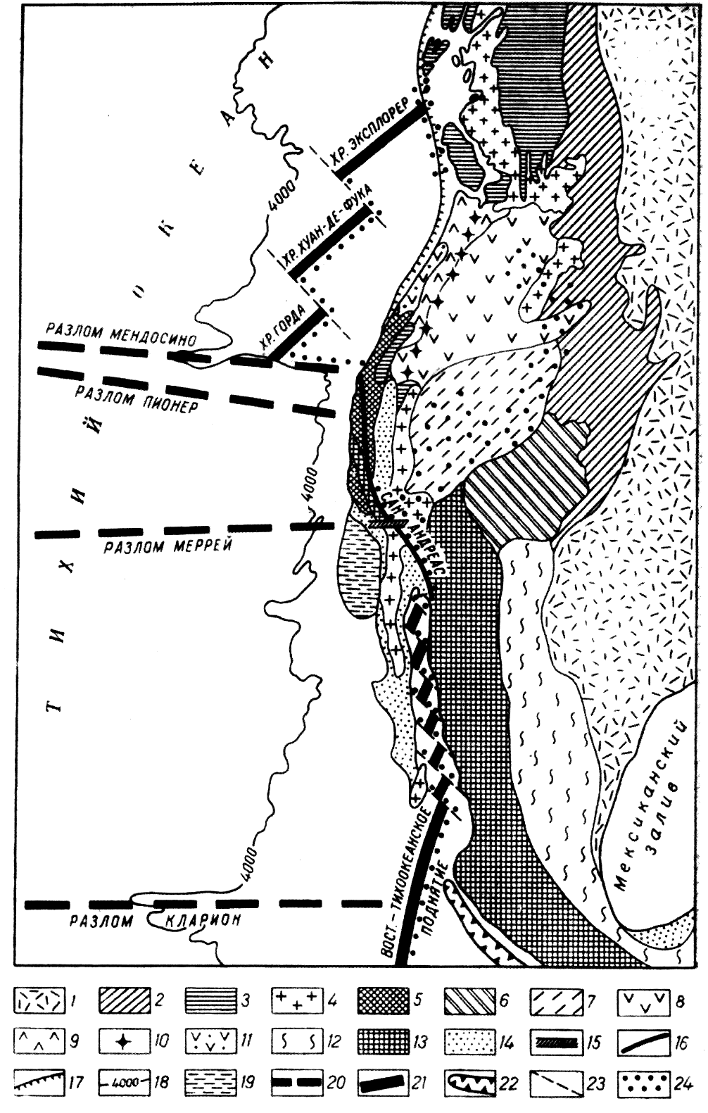
Fig.3 The Melanesian type of the Pacific transition zone according to B.I. Vasiliev [10].
1 – Australian Epibaikal platform; 2-5 – folded zones: 2 – Paleozoic (Tasmanian), 3 – Lower Mesozoic, 4 – the same, activated in Paleogene, 5 – Lower Cenozoic; 6–8 – superimposed basins: 6 – Upper Cretaceous, 7– Paleogene, 8 – Neogene; 9 – island arcs; 10 – deep sea trenches; 11 – intra-oceanic trenches; 12 – Pacific Ocean mega-trenches ; 13 – Mid-ocean ridge axial zone; 14 – steps and plateau; 15 – main fractures. Roman numerals in the circles – chains of the Australian-Melanesian sector: I – New Guinea; II – Western Melanesian; III – Solomon; IV – New Hebrides; V – Tonga-Kermadec; VI – New Zealand; VII – Macquarie.
Upper Cretaceous granite and granite-diorite batholites). These processes are developing without any subduction (Benioff zone and DST are absent), i.e. without involving oceanic crust and sediments . It is also noteworthy, that some particular regional structures – Valley and Ridge Province or Great Basin, Columbia Plateau of trap rocks (N12), display a mysterious right cross shift of the San-Andreas, known as the Transverse Ridge, the Californian marginal underwater plateau (similar to Blake Plateau to the north from Florida in Atlantic) and similar. The section comprises a big oval basin (NE axle is1000 km, NW – 600 km) and is a young (N2-Q4) sub-isometric field of “group, or scattered rifting” due to the regional spreading in the ENE direction, and horsts and grabens of the NNW extension formation in-situ, and at the sanme time as the arched uplift (from P3 or from N1) formation. In the NNE direction this field is also substituted with oval, but with a slightly greater trap-rock magmatism field in the Colombian Plateau, and to the SSW and W it is limited with granite and granite-diorite batholites (mainly K2). Over all the whole area, the Earth’s crust is reduced to 18-20 km (probably, mainly at the expense of the “third” layer); the velocity of seismic waves of the uppermost mantle is decreased (7.8 km/s), and heat flow is strong, whicht is typical for PTZ (as well for NW China [48, 91]). All this implies the crus’st preparation for taphrogenesis with AS+ID system, or the formation of the next segment of the oceanic floor.
In the ocean, the Columbian TZ is outlined by Belousov with a 4000-m isobath passing at 1000-km distance from the coast. This very flat, wide, gradual, but stepped transition from the continental slope to abyssal deeps is: firstly – the inheritance of its primary continental origin, and, secondly – of the superimposed arched uplift in the south presented by three ridges – segments of the "spreading" ridge: Gorda, Juan de Fuca and Explorer. Their zone intersects the continental structures and is parallel to the arched uplift on the continent displaying indifference of these forms to the type of crust. In the Jurassic and Cretaceous Periods this portion of the Ocean supplied material to the Cordilleras geosyncline. Even after basalts aerial eruption, in many areas of this TZ in Paleogene and Neogene, the continental and shallow-water bodies which now lie at a depth of some kilometers, can be distinguished [5],
Some Conclusions on East Transition Zone. The structural complexity of ETZ and its dissimilarity from WTZ are mainly explained by its prolonged (Paleozoic - Quarter) tectonic activity and stability at the same place resulted in the superimposition of formations belonging to three-four tectonic and magmatic cycles; and till now the Cenozoic oceanic cycle has been considered as the last one. All the previous cycles were intracontinental: regions of the modern EP and SP (at least their eastern parts) supplied terrigenous material both to the Andean (reconstructed Arequipa continent [10]), and North-American [5] (Franciscan series) geosynclines. In Columbian TZ, marginal plateaus have sunk to different depths, for example, the Californian - to 1-2 km. On its surface there are subaerial basalts (dating back 4.8 and 1 million years): this major part of the continent (350 x 200 km)was submerged only in the Pleistocene. Crust thickness reduces as it approahes the shelf; at California it is from 30 to 20 km and farther it reduces to 10 km: this has already been the oceanic crust; and at a distance of about 1000 km from N. Americ, thea continental slope gets thinner, (almost two times) which is a repletion in reverse of the CC thinning in ETZ, for example in the Philippine Sea [106-108]. Only one satisfactory explanation of this empirical relationship exists – centroclinally increasing CC oceanization and its substitution by the oceanic crust. And here, there are no signs of the ocean’s continentalization. nor, obverely, is there any wekening of the ocean’s transgression onto the continents; however here it is mainly developing within the continent, inside the lithosphere.
Pacific Ocean Ring (PR) – in terms of geotectonics is a mobile belt incorporating the main part of TZ, or CM, and pericontinental fold (FB) and volcanic belts (VB); sectionally, it is multiple-aged (Riphean – Cenozoic), in terms of structure it is sharply ingomogenious and of different widths (from 4-5 thou. km in the west to tens of km in the subsea Macquarie Ridge in the SW, or about zero, if to take into consideration the Antarctic PTZ, where the "ring" is opened). The PR structural integrity is seen in its conformity with the modern outline of the ocean (more precisely, relative to the floor with oceanic crust), and in sub- parallel orientation of FB, VB, ID and AS belts. Although, there are a lot of overestimations and simplifications here, on most sections such conformity can be seen at a glance. But, what genetic sense does it have? At present, there is a periclinal, more exactly, a westward and north-westward delineated incursion of the oceanization to the continents; and afterwards, an EP formation, for the time being only latent and potential in the easerly direction. But, if the oceans of the modern type had not existed before on the Earth, such genetic conformity could not have resulted. There remains only one geologically "consistant" explanation that is the causal connection of the ring belts with the central part of the earth crust expressed in two-three forms: 1) rigid block of CC (craton) – and circum-continental mobile belt (belts) shaping up along with the first; 2) split and moderate separation of the craton parts – and interblock mobile belts and 3) blocks of CC submerged due to the oceanization (not only in AS, but this may be also in many depressions of the central part of the Pacific) – and seamount chains having surrounded (and surrounding) them.
PR or Pacific Ring Belt (PRB) – for the most part the integrity is only apparent. Mainly and the most probably, this is a multiple-aged passive (on its peripheric position relative to the ocean superimposed on the continents) "assemblage" of fragments of cratons and multiple-aged intercraton and peripheric movable belts. In the central parts of the ocean these cratons, FB and VB seems to be sufficiently oceanized and submerged into the lithosphere and mantle. The biggest and the youngest known to date are the unprecedented, superimposed non-conformed mobile belts – EPR and SPR. These are also spreading to TZ (California Gulf, British Columbia). They started to grow in Miocene, almost simultaneously with MOR of other oceans [47], including the Antarctic Ocean. In the latter, such an uplift – the Gakkel Ridge – remains practically as originaly formed, almost synchronous with the taphrogenesis start (Amundsen and Nansen basins) inside the supercontinent of North Pangea which not long ago, in Mesozoic, incorporated all north continents, their shelf and Arctic. But why MOR is not available in the noticeably more (than Africa) oceanized WACM, which, not without reason, is identified [51] with concentrated spreading zone of the first order? Or the formation of such orogenic uplifts is not strictly connected with the oceanic crust?
Summary A common feature of both WACM and EACM is the absence of any signs of changing oceanization to continentalization: nowhere has the destructive( for the continents) oceanization changed to the opposite process. Alhough the marine transgression to the American continents, after EP formation, had just begun developing in the first phase of a new cycle, in the form of the intralithosphere preparation (basification) of a big zone of American continents, the continent-ocean borderline has stabilized at this stage.
Continentalization of the Ocean became a bottleneck in Plate Tectonics: a full Bertran cycle has completed, but oceans closing has not ensued, to the contrary, new oceans have even emerged theArctic. For this reason, the Russian followers of Plate Tectonics cherish the hope that Koryakia is on the segment of a new crust S Koryakia is the segment of the Pacific Ocean in which, supposedly, still in the Lower Cretaceous, the oceanic crust subduction under the continent, huddling, folding prepared the formation of a new crust from the oceanic crust . Since then, the continent, seems to have, gradually has been moving to SE: and now, on the front line of its invasion is the Aleutian Island Chain that is considered as a new continental formation on the oceanic crust, regardless of the bare facts (ancient continental basal complex and non-oceanic Cenozoic formations) indicating that it has remained (as borderland) from the oceanized continent [84, 85, 87-93, 95, 103 et al.]. Till now some geologists believe that the back-arc basins (Commander and Aleutian in the Bering Sea) with (sub)oceanic crust are a part of the ocean fated to continentalization. But real geological history, which easily may be established,has disproved that "scenario" evidently written for the theory only. In the Lower Cretaceous period Koryakia was located at least in 2 thou. km (more likely much farther) from the ocean. It is now at a distance of 1000 km from it. Going back that to the period in question, then not only the ocean's north-western angle with the Imperor Ridge, Hess, Obruchev and Shatsky Rises, but, probably, the north-eastern angle, too, was continent [9, 11, 111, 120]. Basal complexes of many rises and flank islands (particularly near Alaska) of the Aleutian Island Chain include Mesozoic, Paleozoic and maybe older rocks [7, 78, 91],such as the Kamchatka – Kurile –Japan island chain. The Aleutian Island Chain is not a pure oceanic superimposed VB, but a borderland, the CC remnant oceanized in different degree. All exposed on the surface formations of the (P-Q) island chain are continental [93,103]; and material for Paleogene clastoliths was brought from the south, from the ocean. Most likely, that the ocean approached the Aleutian Island Chain only in Miocene; and when invading Beringia overcame it [103] and there appeared subisometric Commodore and Aleutian basins with (sub)OC.The South part of the Bering Sea – is not the relict of the ocean, but a new formation – a young superimposed taphrogene basin on the site of the CC section and underlying mantle diapir. Kariakia was and has been an intracontinental fold belt that, evidently, never had contacts with the ocean. Nevertheless, in the future they may meet, if the trend of the ocean transgression continues here.
Sometimes, island volcanic chains, emerging on the OC owing to the volcanic accumulation, are used as examples of continentalization. Though, there are a lot of such chains and ridges in the ocean, they are only parts of the ocean, and not of continents; and the continents were not composed of such parts, in any case this fact has not been described. This is simply a phase of the ocean’s development.
Geological and evolution resemblance of WACM and WP, and their gradual transition into each other in some places – is an evidence of their identical genesis. As we are going to show below (Chap. 5), they have formed in the consequence of CC basification (oceanization) and taphrogenesis, which in WP was developed more. Similarity between WACM and geosynlines of the past confirms that fact, doesn't allow to fully identify the latter with WACM and moreover with the modern oceans. Even the closest in age, the Alpine FB started almost synchronously with the oceans as a geosynclines and, being close to WACM has exceeded it in complexity, size and oceanic maturity, i.e. in its degree of oceanization and position in the earth's crust structure: It has never been perioceanic, which might have threatened the oceanization of the Thetis or its outer part (which has not happened) and to avert the apogeosyncline finale. The Thetis "Ocean", as well as WACM, consisted of subisometric depressions and stretched mountain trenches of moderate sizes (to some hundreds of km) with (sub)oceanic crust with a few ridges separating them – CC remnants and volcanic ridges. The main difference between them is the folding and thrusting of Alps, and absence in WACM indicators of overall compression; the folding of overall compression may absent here completely.
CHAPTER 5. MAIN FEATURES OF THE GEOLOGICAL HISTORY AND THE PACIFIC OCEAN ORIGIN
Geological History is seen as the rows of actual sequences – geological bodies of different levels, partly shown above (Chapt. 1-4). The comparative geological method facilitates their historical interpretation, particularly – close resemblance of WP and WACM [91, 92] and their dissimilarity from EB and SP. The rock documents found in the modern Pacific Ocean boundaries anyway can be subdivided into oceanic and pre-oceanic. Pre-oceanic rocks relate to the basal complex; fragments heaved by drag-buckets from fracture escarps and from steep slopes of remnants and rises provide for information about this basal complex. The Upper Triassic basalts of Tahiti island [15] and other WP points, probably, pre-oceanic, but occurring in the cross-section, begin the first volcanic megacycle (T3-K1) – the ocean formation cycle, which a long period of time had been developing on the continent. At the end of the Paleozoic and in the first half of Mesozoic, the continent existence on the place of WP has been already supposed to be proved, and different concrete facts evidence it (Ch. 1-3): multiple CC remnants, rocks and geochemical marks of continents, continental and shallow-water basal layers of the cover, weathering crusts, trap-rock type of initial volcanism, basalts porosity and etc. In the future ocean, the WP crust was first to undergo the destruction which got apparent on the surface at the end of Triassic or Jurassic. A long-term intra-lithosphere CC transformation (P-T) preceded to that: intrusion of ultrabasite-basite dykes and other intrusions, fluid-magmatic alteration of the crust of metasomatic type – basification, or oceanization.
According to the data available now, abyssal destruction and crust substitution consequences, first of all, occurred in the block with Mariana Trenches, though some other WP areas did not fall astern of it, and have a chance to overtake (Chapt.2, 3). In the Upper Jurassic and Lower Cretaceous period, the flooding of the continent interior plains and shallow-water basins with plateau basalts, which may be used to judge about the mass ("scattered") rifting, was continued. In Lower Cretaceous the volcanism was followed by sinking of blocks; in Upper Cretaceous it increased when toleitic volcanism became the most intensive and diversified (including KLAEP, MOR, subalkalic and other basalts), and the rifting became more concentrated. At the end of Cretaceous, the regional volcanic accumulative ridges were formed from the more diversified volcanites; and structure of CC remnants and rises became more complicated (MidPasific, Imperior, Lin, and afterwards - Hawaii). By the end of Mesozoic, WP looked like now. And the "superconcentrated rift" – MOR has not emerged then. In other oceans in this phase it has not appeared, too. Depressions had depths of 3-4 km (red clays had not yet formed), and their sizes were limited by the WP central part; mainly to the north from the equator, but without northern Aleutian part. In the early Cenozoic, heat flux decreased in the central part of WP, volcanism got weaker, tectonic activity lowered and sedimentation slowed down, in the deep areas of the depression floor it has changed to the underwater weathering: red clays were for certain found in Oligocene (in some places they may be of Eocene age). It means ocean spreading to the north, probably, almost to the present-day borderline of the Aleutian islands, and to the south – to Australia. In such position WP can exist hundreds of millions of years, if not forever.
It is evident that in the oceanization process the WP north-west and north [45] with Shatsky, Obruchev, and Hess rises were the last formed. Here the sedimentation relationship with continents had been maintained up to Miocene. And western, northern, eastern and local terrigenous drift created thick (up to 2 km, together with the background diatomites and limestones), probably, turbidite beds (as on the Aleutians during the same period of time). Apparently, just only in Pliocene, DSTs occurred in the west and in the north were the catchers and traps for terrigenous material. In the ocean north-east, in the Alaska-Canada sector, turbidites are spread out to the west and south-west for thousands of kilometers till now. In the anomalously thick (to 22 km) crust of the CC rises may remain relicts. This fact is confirmed by the lifted from the floor granitoid, crystalline schist and other CC rocks [8], which in many aspects are similar to Kamchatka rocks, as well as xenolite in Hawaii lavas (garnet pyroxenite with the age of > 3 billion years [112,121]).
In SP with its passive margin, it seems that in Cenozoic the heat flux had never reached the intensity which the flux had in EP (maybe it is connected with a proximity to the Pole?), and magmatic and tectonic activities were comparatively weak. Maybe it is the reason why the largest continental blocks have been non-oceanized here – minicontinents of Campbell, Chatham in the West and reconstructed Arequipa [11, 14] in the West. The all-round inactivity of SP block can suspend its future development too, in this case a deep-water plume (as in Arctic) and deglaciation of the Antarctic Continent will be able to change the situation.
SP and WP have only Cenozoic, less documented (as compared to WP) history. Some their geological features common with WP (crust sections in basins and similarity of original volcanites) permit to reconstruct the first phase of EP as a traprock formation on the land and then their subsidence to the present depths. Indeed, under the basalts of MORB type, plateau basalts were found (drill holes157, 320, 321), but their basal flows have not been accessible till now. On-land trap rocks or their analogues are possible. The basalt formation of the MORB type has accumulated here since Paleogene, but it was connected not with EPR and SPR that, obviously, did not exist at that time, but with local rifts similar to those active in the present time in the Juan-de Fuca, Naska, Coconut Ridge and others. In the early phases of EPR and SPR grow in Miocene, the similar basalts of MORB type extruded from the same or analogues chambers; and they were probably distributed over the first tens of km.only.With building up of rises and during heating up of the rift and wider zone, ingress and circulation of the ocean water intensified. The hydrothermal process, which included metal mobilization, loss and sedimentation -- both as chemogerms 'smokers' and as the metal-containing sediments [33] -- must have become a predominant form of the volcanic activity. In addition to this sedimentation formation, hydrothermal eluvial process created volcanic 'weathering' crust, which must be formed by palygorskite, smectite and other clays, opalolite, allite, sulfidolit and other ores (ore deposits of secondary quartzite types and other ).
During the Cenozoic period the floor subsidence was developing, and in some places with downwarping. When the volcanic activity became weaker in the most depressions of EP and WP, a large-scale continuous halmyrolysis has started; and the process of red clays accumulation started that time has not terminated and has been in progress till now. That indicated that the floor subsidence up to CDC took place at larger areas, isolation from the terrigenous material became better and, on the contrary, cold subpolar waters suppressed the obstacles preventing full circulation of the bottom waters. In the most depressions, for example, to the east from the Lain Ridge and in the Clarion-Clipperton Fracture Zone, red clay beds overlie nanoplankton limestones of the writing chalk type (Marquesas and other formations-stratons), this fact indicates substantially lesser depths (higher than CDC) of most EP blocks and partly SP in the Early Cenozoic. Diachronous replacement of the calcareous sediments by the formation of halmyrolytic red clays definitely records place and time of the floor subsidence lower than CDC, sensitively reflecting 'vertical' dynamic of the sedimentation and tectonic events.
Pacific Ocean Origin – is the problem number 1 in the modern geology. Finding solutions to this problem will help to understand the genesis of other oceans and more confident reconstruct their geological history with determining their place in the Earth's history; moreover, a long-term geological forecast will become more confident and main problems of the applied geology will find their solutions: prospecting (mineral resources), engineering geology, and eco-geology. In the modern, extremely polarized geology, two main lines of attack on the problem have developed [33, 94]: mobilist and mainly fixist with eclectic elements; in between there is a row of intermediate approaches, sometimes more eclectic, i.e. more geological, based on: 3) ideas of the Earth moderate expansion and alternating of its expansion and contraction phases [49, 50] (pulsational hypothesis); 4) ideas of the original asymmetry of the Earth and considerable age of the Pacific Ocean [62-65]; 5) concepts of the block structure of oceans and continents and their complicated eclectic, more realistic development [30-33].
Almost half a century the neomobilist hypothesis of Plate Tectonics [20, 76, 109 et al.] has been active elaborated getting now a theory [94]. There are its main provisions: 1) the ocean is created by the spreading of continents, that means that in the divergent zone a new earth crust is forming from the mantle melting; in the Pacific Ocean such generator is situated in the EPR and SPR axial zone; 2) at the same time with the spreading, the opposite underthrust zones (convergent and subduction) of the ocean crust are laid under the continents, including in the places where the continents are dipping into the mantle: in the western and in the eastern seismic focal zones around which the island arcs are emerging with andesite, dacite and riolite – a new continental crust; 3) oceans are finite in time, small oceans live 150-200 million years (Bertrand cycle in a new interpretation), big ones – to 650 million years (Wilson cycles); closing of oceans, evidently, is the consequence of the spreading/subduction rates change (с>1 for c<1); 4) first cause of the continental drift is the mantle convection able to displace them to thousands of kilometers; 5) geosynclines – are the oceans of the past, for this reason we should recant a duplicate term and notion; 6) fold belts are the closed oceans.
Criticism of this scenario is widely known [5-12, 14-16, 21-23, 38-44, 50, 52, 55-60, 66-74, 77, 80-82, 84-108, 110, 111, 113-116, 124 et al], and here we will mention it as much as required to solve the problem of the Pacific Ocean origin. Above, in chapters 1-4 and chapter 5 (geological history), we have presented some concrete facts which fall beyond the Plate Tectonics, shifting this theory to the second subordinate place in the Pacific Ocean genesis. Summary of the main statements and facts negative for the maxi Plate Tectonics: 1) inconsistency of the monospreading (from EPR + SPR) mechanism, 2) failure to prove subduction and 3) immobility (more or less) of main structures of the sea floor and magma-producing chambers; 4) absence of geological evidence of the oceans closing and, at least, shifting from oceanization to continentalization in the somewhere place; modern oceans 'have come for a long time if not for ever', because forces and mechanisms of their ‘disappearance’ are not seen even in the theory [91, 94] (mythical subduction is not counted); 5) geosynclines of the past were not oceans; 6) most of the largest endogenous deposits have been formed during hundreds of millions of years in one and the same place by recycling predominately one and the same substance, i.e. fixed; and horizontal migration of plates is contra-indicated to the mineragenic maturing. Particularly, the Plate Tectonics is weak and vulnerable in details, in hundreds of concrete facts, i.e. in the regional and local geology – such is a destiny of all 'monotheories' in the historical sciences [94] when simple and 'single-answer' theories always turn out false and harmful.
The alternative to the Plate Tectonics is the growing into the theory hypothesis of basification of the continents’ earth crust leading to their organization and taphrogenesis (according to V.V. Belousov [5, 6]). These processes (having been developed in the conditions of more or less, but critical in the close-up, spatial immobility) and their derivatives have been considered in all chapters above and in [5, 6, 9, 23, 41-44, 56, 57, 66, 77, 91, 97-101,116]. Main facts: 1) the rounded or sub-isometric shape of many depressions means the impossibility of their co-formation from the one spreading zone, and admits only a local low-amplitude spreading as a consequence, for example, of the magmatic diapir uplift, which is of the same or close dimension and shape; 2) the evolution of magmatism required during many tens of millions of years stability of the magma chambers not only in the mantle, but relative to the layers of the crust, too; 3) rectilinearity or small curvilinearity in any direction of the differently-directed linear structures and the ridges between trenches, for the except of some sections of the later forms (MOR, ID, DST); 4)Block patterns, mosaicity of the crust and lithosphere (and may be a more deep mantle) of the ocean; 5) remnants of the continental crust, and the small and big continents reconstructed on them (particularly in WP), which till now in some places compose an integrated pattern with the 'parent continent' (underwater Campbell Plateau, Chatham – New Zealand-Australia and other); 6) subaeral and shallow-water initial volcanites and sediments, and the clear indicators of the floor subsidence, sometimes very quick; 7) actual and geological history of the regions and the ocean as a whole – is a touchstone and the last criterion for hypothesis and theories.
The principal scheme of the evolution phases and details of the processes which are important for understanding the genesis of the main, central parts of the ocean, at least the Paleo-Pacific (WP), may be got from the well studied [7-11, 21, 22, 29, 76, 83-113, 115, 117-120, 122, 123] Western Continental Margin. This is a modern geochemical laboratory producing oceanic crust for marginal seas from the continental crust. This oceanic crust is separated from the ocean with the low-shifted or not-shifted-at-all remnants of the continents – borderlands and superimposed volcanic belts which form their own island arcs on the oceanic crust. There are juvenile phases of many trenches of WP and its ridges, which have gone forward in the oceanic evolution and have lost (if existed) some types of ACM volcanites, e.g. calc-alkali. The reach and diversified volcanism of CMs draws them closer with marginal volcanic belts and eugeosynclines of the past – for some types [7-11, 14, 21, 22, 84-88, 91, 92, 95-113, 115, 117-122], and with oceans – for another types; but, nevertheless, this volcanism has some distinctions from both of them.
What is the basal complex of the oceanic crust and why there are so many differences between EP and SP compared to WP and WACM? If to judge by the CC remnants prevailing in EP and SP [8-11, 14, 15, 82] – the oceanic crust is laying on the continental crust or its basal fragments. If the basal complex in EP and SP is really ultrabasite-basite and its composition is close to the Paleozoic South Ural eugeosyncline megatrench, it, probably, surpassed this one in area and degree of 'basitivity'. But the question remains: where to the huge volumes of "acid", sialitic matter have gone? In Yu. M. Pushcharovsky model [61-65] this question is omitted "by definition", because the Pacific sector in whole with its maximal basite-ultrabasite development, apparently, has never been rich in granite material. But, avoiding by such a way one question we have got some another: whether it is possible to find anywhere on the Earth the segment with constant active endogenous conditions? Whether it is a rule – correlation of the depths activity with increase in silicate material production, so called "stone foam" – unavoidable result of the deep differentiation of material during numerous endo-exogenous cycles? A negative answer to the first question and a positive answer to the second one allow for considering some pre-existing oceanic basite-ultrabasites as not very old, and encourage searching more persistently for the traces of acid magmatism.
The open-minded geological approach, based on sparse data so far, leads to only one modest assumption about the modern ocean precursor and its pre-existing oceanic basement: that was the system of continents-cratons and separating them apo-evgeosyncline belts; correspondingly, in different regions of the ocean the rocks of more ancient age and type could underlay the young oceanic basalts. The occurrence of the deeply-metamorphized rocks – granulites and fragments of eclogites and gneisses, as well as the remnants of CC, almost everywhere in the ocean evidence that fact. Lead isotope ratios [12] in the EPR galenites, as well as Kuril Island Chain, Japan and Kamchatka, have shown that the 'leads' of WACM and EPR could not have the same source, and could not be produced as a result of the source differentiation, because they have completely different lead-isotope trends; and to obtain them by mixing the sediments with tholeiites in the Benioff zone is impossible. This fact excludes the participation of the EPR sediments and basalts in the process of production of volcanite lead and region ores. Lead isotope ratios analysis for the Japan Islands has shown: the crust with the island arc 'leads' corresponds to the metamorphic rocks of the Hida Belt, which A. Miasiro (1976) assigns to the category of grey gneisses, typical rocks of the Achaean CC. According to calculations, evolution of the Hida gneisses lead which took place in enormously different conditions: from the moment of the Earth’s creation to 3700 million years (typical crust parameters), and from that frontier up to the present day (crust-mantle). This is a one more evidence of the CM foundation in this sector on the Pre-Cambrian basement, but not on the moved up oceanic crust. According to isotopes of K, Ar, Pb, Sr, Nd [Mac Ken et al., 1983; 112, 119, 125] under the Aleutians, Hawaii, Society Islands, Marquesas and et al. the mantle of the continental lithosphere is found with the age of 3.5 billion years.
To explain the difference between EP+SP and WP+ WACM is more difficult, because the first pair has the same young age (Cenozoic), as WACM, but the relief and structures differ dramatically. The relief of EP and SP was smooth and is smooth now, hilly, but not ridged (for the exception of only one volcanic mountains). In the middle of its short history (<30 million years) the relief was perturbed by the uplift of the swell-type rise (EPR + SPR), which is absent and was absent (and probably will never appear) in WACM and WP. There are the corresponding distinctive features in the tectonic structure. For the time being, it is hard to explain the differences.
Conclusion
The investigated materials and the Pacific Ocean documentary history based on these materials permit to draw some general conclusions.
1. According to the sea floor structure, the ocean is sharply nonuniform and unevenly-aged; as a rough approximation, the western (Western Pacific + Western Active Continental Margin, WP and WACM) and the eastern (Easter Pacific, EP+SP) region may be considered, as really different oceans: the western 'ocean' has an older, Jurassic-Cretaceous crust in the center and mainly Cenozoic WACM, which structure resembles WP; the eastern 'ocean' is simpler and more uniform, mainly with the Cenozoic crust.
2. These parts of the ocean have formed independently (not from a single center or zone) and on the place of their present-day location, without any large-scale displacements; vertical movements dominated, often with subsidence, in different blocks, sometimes they are very fast, collapsing, leaving behind pillars of the continental crust (CC); from the noticeable horizontal movements – the faults are the main type, mostly in the eastern part.
3. In the Pacific Ocean formation, volcanism was the main 'surface' process, most intensive at the outset (probably, the phase of increase the intensity we are not yet able to see) in the first half of the history of the each of its parts, but weakening in the second half. In WP the first volcanic period lasted more than 100 million years (Jurassic and Cretaceous); in EP, SP and WACM it began 25-30 million years ago and has lasted until now, but less intensely. At the same time, in WP, a considerably depressed hot-spot volcanism only were accompanied by sedimentogenesis and lithogenesis. The volcanism evolved from the outwells of 'non-depleted' plateau basalts to the basalts of MORB type and further to subalkalic and rarely to alkalic basalts, and low-volume alkalic basalts. These facts indicate the fixed position of the ocean floor over the mantle chambers, usually getting sufficiently deeper at the end of the evolutionary cycle (not more than 100 km).
4. Sedimentary formations gradually substituted volcanic formations at the same time and place, and in Cenozoic they became dominant. Since the Late Cretaceous the typical oceanic formations 'have ripened' more and more: planktonogene chalky and diatomite, and especially a halmyrolytic red clays with Fe-Mn noddles also occurring in the Indian and Atlantic oceans. It signifies the emerging from the early Cenozoic of the vast (from Pole to Pole) ocean with the depths lower than critical for carbonates almost within a half of its area.
5. The oldest, Late Triassic and (or) Lower Jurassic basalts of the ocean are practically identical to the continental platform trap rocks; they have clear signs of the outflow in a sub-aerial environment, and that fact is confirmed by their porosity, types of sediments and subaerial eluvium. The continental trap rocks of the sea floor depressions and residual mountains are the first messengers from the mantle and lithosphere, evidencing that CC had started its transformation or that the transformation into the oceanic crust had just been in progress. While submerging, trap rocks and their oceanic analogues – plateau basalts – lost their shallow-water features step by step. The composition of melt-outs was changed slowly (during tens of millions of years). The types of melt were getting closer to MORB, and in the Upper Cretaceous and Cenozoic, during deepening of chambers or intensification of mobilization and eluviation of alkali and associated rocks, the basalts became subalkaline and in some places alkaline.
6. Now, geological structures, ocean history, evolution of magmatism, and sedimentary formations undoubtedly indicate a general pattern for the formation of the ocean – taphrogenesis, with submersion of the basificated areas of continental crust without their essential horizontal displacements. It was caused, according to V.V. Belousov’s hypothesis, – by the crust basification, initiated by the deep mantle plum(e)?s, carrying fluids and heat from outer core (D). More detailed the process is studied by petrologists and geochemists.
7. The contemporaneous view of the development of the modern oceans’ in the mid of Mesozoic testifies to the start of a new oceanic period in the Earth's history. In the pre-oceanic period (with huge sea floor areas without granite-metamorphic layer of the crust and the 4-5 kilometer deep water formation), probably, such oceans did not exist, as the sedimentary formations indicate. The fold belts of continents were developed not from the oceans, but from the geosynclines; and to substitute the latter for the oceans is the main false assumption in the Concept of Plate Tectonics which has held geology back.
8. The continuing tendency of marine transgression (ocean-formation) will provide for the central parts of the oceans preservation for a long period of time, if not for ever.
What has remained unclear for the authors: 1) the reasons why the magnetic stripe anomalies contradict with the geology in some places and 2) we leave without comments satellite data on velocities of plates and continents drift (from the geological point of view, the time period of observations is too short, therefore, in terms of history and geology no importance can be attached to those data). The reader will find in our report not only the authors' answers to this topical problem, but rather , fresh questions on geology and the history of this amazing ocean; and we hope this will inspire our readers to find solutions by themselves. The subject has rich rewards. The authors are grateful to academicians E.E. Milanovskiy and A.A. Marakushev, corresponding member of RAC G.B. Udintsev, Professor L.L. Perchuk, candidates of geological and mineralogical sciences V.A. Ermakov and N.A. Kurentsova for attention to the work, their valuable advice, remarks and help. Many thanks to E.V. Karpova, M.N. Shcherbakova, A.V. Zaitsev, I.V. Frolova, S.B. Ivanov and A. Yu. Frolov for assistance in pictures preparation and formatting. Special thanks to B.I. Vasil’yev, Doctor of geological and mineralogical sciences, whose books provided us with valuable material and ideas.
Bibliography:
- Avdonin V.V., Kruglyakov V.V. Metallogeny of the World Ocean. Moscow: MSU. 2005.190 pp.
- Andreev S.I. Geodynamics and Ore Genesis of the World Ocean. SPb.: VNIIOG.1999.
- Andreev S.I. The Mid-Oceanic Ridge (MOR)//Planet Earth 'Tectonics and Geodynamics'. SPb.: VSEGEI. 2004. Pages 257-259 and 601-604.
- Bezrukov P.L., Murdmaa I.O. Sedimentary Formations in the Oceans // World Ocean History Moscow: Nauka, 1971. pp. 107 -127.
- Belousov V.V. Transition Zones Between Continents and Oceans Moscow, Izdatel'stvo Nedra, 1982, 150 pp.
- Belousov V.V. Fundamental Problems of Geotectonics, Moscow: Nauka. 1989. 380 p.
- Belyi V.F. Marginal and Continental Tectonic-Magmatic Belts of the Pacific Segment of the Earth. Magadan: North-East Interdisciplinary Science Research Institute FEB RAS. 1998. 58 p.
- Vasil'yev B .I. Main Geological Features of the Northwest Pacific Ocean. Vladivostok Far Eastern Branch of Russian Academy of Sciences 1988. 192 p.
- Vasil'yev B .I. Principles of Regional Geology of the Pacific Ocean Part 1 and 2. Vladivostok Dalnauka 1992. 176 p. 242 p.
- Vasil’yev B .I. Melanesian Type of the Pacific Transition Zone//Pacific Ocean Geology 1993. No. 5. pp. 107 -12.
- Vasil’yev B.I, Choi D.R. Geology of Deep Trenches and Island Arcs of the Pacific Ocean. Vladivostok, Dalnauka. 2001. 184 p.
- Volobuev M.I., Stupnikova N.I., Zykov S.I. A Deep Structure of the Kuril Island Arc According to the Pb-isotope Study // MSU Bulletin, 4, Geology. 1987. No. 6. Pp.23 -34.
- Guyots of the Western Pacific and their Mineralization / Yu. G. Volokhin, M.E. Melnikov, E.l. Shkolnik et. al. Moscow: Nauka. 1995. 368 p.
- Geology and Origin of the Pacific Ocean. Ed. B.I. Vasil'yev North-East Interdisciplinary Science Research Institute FEB RAS. Vladivostok Dalnauka 2005. 167 p.
- Govorov I.N., Golubeva E.D., Pushchin I.K. et al. Petrological Provinces of the Pacific Ocean, Moscow: Nauka. 1996. 444 p.
- Golovinskiy V.I. Tectonics of the Pacific Ocean, Moscow, Nedra. 1985. 199 p.
- Golubeva E.D. Tholeiitic basalts of the Pacific Ocean Provinces. Vladivostok. 1990. 135 p.
- Gramberg I.S., Isaev E.N., Levin L.E. Geology and Mineralogy of the Late Jurassic-Quaternary Sedimentary Cover in Oceans and on Continents. Moscow: VNIIZarubezhgeologia 1993. 681 p.
- Dmitriev L.V. Variations of MAR Basalts Composition as a Function of their Geodynamic Environment (in Russian). // Petrologiya, 1998. V.6. No. 4. Pp. 340 -362.
- Dubinin E.P., Ushakov S.A. Oceanic Riftogenesis. Moscow: GEOS. 2001. 292 p.
- Ermakov V.A. Geological Models of Formation the Epicontinental Backarc Basins // Global Tectonic Problems Moscow: GEOS. 2000. Pp.175-192.
- Ermakov V.A. Peculiarities of the Active Continental Margin Development (examples from the Kuril -Kamchatka region) Moscow: Print House RAS. 2002. Pp.158 -188.
- Zotov I.A., Resanov I.A. Magmatic Substitution of the Earth Crust – Possible Mechanism of its Transformation // Newsletter MOIP. Geol. Dpt. 1984. V. 59. No. 5. Pp.3 -13.
- Metallogeny of the World Ocean. Moscow: Nauka. 1971. 288 p.
- Kashintsev G.L. Deep-Water Rocks of the Ocean. Moscow: Nauka. 1991. 283 p.
- Kashintsev G.L. Zhdanov V.V. Amphibolite shist of the Eltanin Fracture Zone (Pacific Ocean) // Reports of the Academy of Sci. of the USSR. Ser. Geology. 1980. No. 8. Pp.28 -37.
- Kogarko L.N. Magmatism of the World Ocean islands and inhomogeneity of the Earth's upper mantle // Solid Crust of Oceans Moscow: Nauka. Pp.113-120.
- Kolobov V. Yu., Konovalov Yu. I., Simonov V.A. Magmatism of the Mussau Ridge as the indicator of its island-arc origin // Nauka. 1988. 754. pp. 67 -68.
- Korzhinskiy D.S. Transmagmatic Flows of Subcrustal Origin, and their Function in Magmatism and Metamorphism. Moscow: Nauka. 1968. pp. 60 -74.
- Krasnyi L.I. Geological interface of the great Pacific Ocean. Reports of the Russ. Acad. of Sci., 1973. V. 242. No. 5. pp. 1148 -1151.
- Krasnyi L.I. Geology of the Pacific Ocean Mobile Belt and the Pacific Ocean. Leningrad: Nedra. 1978. V.1. 264 p. V.2. 248 p.
- Krasnyi L.I. Global Geological Block System. Moscow: Nedra. 1984. 220 p.
- Krasnyi L.I., Petrov O.V., Bluman B.A. (ed.) The Earth Planet. Volume “Tectonics and Geodynamic”. SPb.: VSEGEI print. 2004. 652 p.
- Lisitsyn A.P. Sedimentation in the oceans. Moscow: Nauka. 1974. 440 p.
- Lisitsyn A.P. Problems of the oceanic sedimentation. Moscow: Nauka.1978. 392p.
- Lisitsyn A.P. Lithology of the World Ocean// Earth Planet. Volume “Tectonics and Geodynamic”. SPb.: VSEGEI print. 2004. Pp.28 -251.
- Lisitsyn A.P., BogdanovYu.A., Gurevich E.G. Hydrothermal formations of oceanic rift zones. Moscow: Nauka. 1990. 256 p.
- Lutz B.G. Geochemistry of the oceanic and continental magmatism. Moscow: Nedra, 1980. 246 p.
- Lutz B.G. Formation types of ophiolitic cross sections (the interpretation of ophiolites as remnants of the oceanic crust)// Geodynamic study. No. 13. М.: 1989.P.69-93.
- Magmatic formations of the Pacific Ocean basal complex. Leningrad. Nedra. 1986. 52 p.
- Makarenko G.F. Basalt fields of the Earth. M. Nedra. 1978.146 p.
- Marakushev A.A. Magmatic replacement and its petrologycal function. Phys.-chem. petrology study, issue 14, M., Naukа. 1987. Pp. 24-38.
- Marakushev A.A. The function of geological replacement in the processes of the earth crust formation and substitution. // Global Geodynamics Problems. Issue 2. M.: RAS Print house 2003.Pp. 214-229.
- Marakushev A.A., Moiseenko V.G., Sakhno V.G., Tatarin I.A. Petrology and ore content of the Pacific Ocean // Pacific Ocean Geology. 2000. V.19. No. 6. P.138
- Melankholina E.N. M.: Tectonics of the Northwest Pacific. Moscow: Nauka. 1988. 216 с.
- Menard G.U. Geology of the Pacific Ocean Floor. М.: Mir. 1966. 274 p.
- International Geological and Geophysical Atlas of the Pacific Ocean. G.B. Udintsev (ed.) IOC (UNESCO), RAS. M.-SPb. 2003.
- Milanovskiy E.E. Main riftogenic stages in the China territory. M.: Printhouse of the Inter-Agency Geophys. Committee of the Acad. of Sci. of the USSR. 1991. 148 p.
- Milanovskiy E.E. Geological pulsation in the Earth evolution. Riftogenesis evolution in the Earth history. //The Eart Planet. Volume «tectonics anfd geodynamic». SPb.:VSEGEI. 2004. Pp.41-55; 162-173.
- Milanovskiy E.E. Concept of the plate tectonics ibid. Pp.344-348.
- Milanovskiy E.E., Nikishin A.M. Western Oceanic Rift Belt // Newsletters MOIP Dpt. Geology 1988. V. No. 4. Pp. 3-16.
- Muratov M.V. Origin of the Continents and Oceanic Depressions. M.: Nauka. 1975. 176 p.
- Murdmaa I.O. Ocean Facies. M. Nauka. 1987. 301 p.
- Eart Oceanization – Alternative to Neomobilism. Kaliningrad: Printhouse of KSU. 2004.
- Oceanology. Ocean Geology. Sedimentation and Magmatism. M.: Nauka. 1979. 415 p.
- Orlenok V.V. Earth Oceanization History. Kaliningrad: Amber Tale. 1998. 245p.
- Pavlenkova I.I. Structure of the Earth Crust and the Upper Mantle, and the Mechanism of Substance Motion. //Problems of Global Geodynamics, Issue 2. 2003. Pp.168-182.
- Pavlenkova I.I. Rotation and Fluid Concept. Geodynamic Concept. “Tectonics of Global Rotations”// The Earth Planet. Vol. «Tectonics and Geodynamics». SPb.: Printhouse VSEGEI. 2004.Pp.374-377, 377-380.
- Perchuk L.L. Basification as the magmatic substitution. // Essays of Phys. and Chem. Petrology. Issue14. M.:Nauka. 1967. Pp.39-64.
- The Problem of Earth’s Oceanization / Ed. V.V. Orlyenok. Kaliningrad: KSU. 1983. 149 p.
- Pushcharovskiy Yu.M. Formation Categories of Oceans and Seas. // Reports of the Acad. of Sci.of the USSR. Ser. Geol. 1985. No. 7. Pp.3-8.
- Pushcharovskiy Yu.M. Tectonic Phenomenon of Oceans // Fundamental Problems of Geotectonics. М.: Scientific World. 2001. Pp.174-230.
- Pushcharovskiy Yu.M. Ocean Tectonics. //The Earth Planet. Vol. «Tectonics and Geodynamics». Ed. Krasnyi et.al. SPb. VSEGEI Printhouse. 2004. Pp.226-232.
- Pushcharovskiy Yu.M. The Earth Tectonics. Tectonics and Geodynamics. М.:Nauka. 2005. 352p.
- Pushcharovskiy Yu.M., Melankholina E.N. Tectonic Development of the Earth. The Pacific Ocean and its Formation. M.:Nauka. 1992. 264 p.
- Resanov I.A. Origin of the Oceans. Moscow: Nauka. 1979. 199 p.
- Resanov I.A. Evolution of the Earth Crust Conceptions. Moscow: Nauka. 2002. 299 p.
- Rudich E.M. Moving Continents and the Oceanic Floor Evolution. Moscow: Nedra. 1983.420 p.
- Rudich E.M. The Expanding Oceans: Facts and Hypotheses: Moscow: Nedra. 1984. 250 p.
- Rudich E.M. Shallow-Water Facies of the World Ocean. Earth Oceanization – the Alternative to Mobilism. Kaliniungrad. 2004. 267 p.
- Rusinov V.L. The Earth Crust Basification as a Mechanism of Crust and Mantle Interaction // Problems of Global Geodynamic. Issue 2. М.: 2003. Pp.200-213.
- Ryakhovskiy V.M. Law of the Basalt-Type Magmatism Development in the Oceans. Thesis of Doctorate Degree in Geol. And Miner. Sci. Moscow: RAS. 1999. 68 p.
- Sakhno V.G., Martynov Yu.A. Magmatism and Peculiarities of the Pacific Ocean Main Structures Fluid Regime. // Solid Crust of Oceans. Moscow: Nauka. 1987. Pp.65 -82.
- Semenova G.I., Martynov Yu. A. Structure of the Pacific Ocean Earth Crust // Comparative Tectonics of Oceans and Continents. Moscow: 1987. Pp.85 -94.
- Silan’tyev S.A. Magmatism in Modern Oceanic Basins//Petrology. 1995. No. 1. pp.24 -36.
- Sorokhtin O.G., Ushakov S.A. Development of the Earth. Moscow: MSU Printing House 2002. 570 p.
- Disputable Points of Plate Tectonics and Possible Alternatives. Moscow: OIFS RAS. 2002. 236 p.
- Tabunov S.M., Tomanovskaya Yu.I., Staritsyna N.N. Rock Complexes of the Pacific Ocean Floor near the Clarion-Clipperton Fracture Zone 1989. No. 4. Pp.11 -20.
- Tararin I.A. High-Baric Metamorphism in the Oceanic Crust Rocks (example of the Ophiolite Complex of the Fracture Zone Eltanin, Pacific Ocean) 1997. V. 354. No. 5. Pp.665-668.
- Timofeev P.P., Khvorova I.V., Kholodov V.N. The Evolution of Sedimentation Processes on Continents and in Oceans //Lithology and Mineral Resources. 1983. No. 3. pp. 3-23.
- Timofeev P.P. (Ed.) Lithology of Mesozoic and Cenozoic Sedimentary Cover of the World Ocean. Moscow: Nauka. 1987. 287 p.
- Udintsev G.B. Relief and Structure of the Oceanic Floor. Moscow: Nedra. 1987. 239 p.
- Werael J. Deep Structure of the Continental Margins and Mid Ocean Ridges. // Geology and Geophysics of the Oceanic Floor. Moscow: Mir. 1969. Pp.362- 285.
- Frolov V.T. History of the Northwest Pacific Development in Mesozoic and Cenozoic.// Ocean Nature. MSU print. 1983. Pp.231 -235.
- Frolov V.T. Genetic Typification of Marine Sediments. Moscow: Nedra. 1984. 222 p.
- Frolov V.T. Are Oceanic and Geocyncline Formations Identical& // Formations of Sedimentary Basins. Moscow: Nauka. 1986. Pp.37 -44.
- Frolov V.T. Historical and Geological Approach to Dividing of Paleogene and Neogene Deposites of the Komandorski Islands // Historical Geology: Results and Prospects Moscow: MSU print. 1987. Pp.107 -122.
- Frolov V.T. Evolution of Sedimentation in the Pacific Ocean Northwest Margin // Sedimentary Cover in Space and Time. Moscow: Nauka. 1989. Pp.155 -164.
- Frolov V.T. Lithology Book 3. P. III Geological Foprmations. Moscow: MSU Printing House 1995. Pp.62-352.
- Frolov V.T. Historical Geodynamic of the Eastern Margin of Asia // Tectonics, Geodynamics, and Magmatic and Metamorphic Processes. Moscow: GEOS.1999. V. 2. Pp. 243-245.
- Frolov V.T. Eastern China: Criteria of the Continental Crust Destruction. // MSU Bulletin, 4 Geology. 2000. No. 2. Pp.23 -32.
- Frolov V.T. Geological History and Geodynamics of the Western Pacific and Ocean Origin // Neogaea Tectonics: General and Regional Aspects. V.2. Moscow: GEOS. 2001. Pp.274 -276.
- Frolov V.T., Rostovtseve Yu.V., Shcherbakova M.N. Cenozoic Sedimentation in the Kuril and Komandorski Islands Zone. Report 1 and 2 // MOIP Bulletin . Geol. Dpt. 1997. V.72 No. 1. Pp.14 -22. V. 73. No. 1. Pp.57 -63.
- Frolov V.T. The Science Geology: Philosophic Analysis. Moscow: MSU Printing House. 2004. 158 p.
- Frolov V.T. Lithogenesis of Oceans. Pages 251-257. Lithogenesis of Active Continental Margins. Pages 301-304. Lithogenesis of Passive Continental Margins Pages 321-322. The Earth Planet. V. “Tectonics and Geodynamics” SPb.: VSEGEI print. 2004.
- Frolova T.I. Magmatism of Mobile Belts and Oceans. Comparision and Conclusions. Bulletin MOIP. Geol. Dpt. 1996. V. 71. No. 4. Pages 4-19.
- Frolova T.I. Magmatism and Origin of Taphrogenetic Basins // Problems of the Tectonosphere Evolution. OIFZ RAS Moscow: 1997. Pages 298-317.
- Frolova T.I. Function of Magmatic Processes in the Earth Crust Transformation. MOIP Bulletin. Geol. Dpt. 2001. V. 78. No. 2. Pages 7-24.
- Frolova T.I. 2. Magmatism of Marginal and Interior Seas and Their Formation // Problems of Global Geodynamic, issue 2 Moscow: RAS. 2003 p. Pages 247-275.
- Frolova T.I. Magmatism of Oceans. //The Planet Earth. Volume 'Tectonics and Geodynamics'. SPb.: VSEGEI print. 2004. Pp. 264-274.
- Frolova T.I. Magmatism of Active Continental Margins // The Planet Earth. Volume 'Tectonics and Geodynamics'. SPb.: VSEGEI print. 2004. Pp. 289-301.
- Frolova T.I. , Frolov V.T., Burikova V.A., et. al Belts of Island Arcs.//Volcanic Belts of the Asia’s East. Moscow: Nauka. 1968. Pages 354-373.
- Frolova T.I. The Origin of Volcanic Series of the Island Arcs. Moscow: Nedra. 1985. 275 p.
- Frolova T.I., Konovaslov Yu. I. Volcanism of the Sea of Japan as the Indicator of its Formation. MSU Bulletin. Geology. 1985. No. 4. Pages 54-74.
- Frolova T.I., Zlobin T.K. The New Data on the Kuril Arc South Part Deep Structure and Some Petrological Consequences. // MSU Bulletin. Geology. 1987. No. 1. pp. 3 -15.
- Frolova T.I., Perchuk L.L., Burikova I.A. Magmatism and Transformation of the Earth's Crust Active Margins. Moscow: Nedra. 1989. 259 p.
- Frolova T.I., Burikova I.A. Magmatic Formations of Modern Geotectonic Environments. Moscow: VSEGEI print. 1997. 319 p.
- Frolova T.I., Burikova I.A. Plateau Basalt Volcanism and Ocean Formation // Disputable Points of the Plate Tectonics Theory and Alternatives. Moscow: IPE RAS 2002. Pp. 30-48.
- Khain V.E. Tectonics of Continents and Oceans. Moscow: Nauchnyi Mir 2001. 606 p.
- Choi D.R. Structure and Composition of the Crust in the North-West Pacific // Deep Structure of the Pacific Ocean and its Continental Surroundings. Blagoveshchensk.1988. Pp. 20-21.
- Choi D.R., Vasiľyev B.I., Tuezov J.K. The Great Oyashio Paleoland. A Palaeozoic-Mezozoic Landmass in the Northwestern Pacific (Critical Aspects of the Plate Tectonics Theory). Theophrastus publ., Greece. 1990. v. 1 p. 197-213.
- Fray F.A. The origin of piroxenites and garnet piroxenites from Salt Lake Crater. Oahu, Hawaii: trace element evidence //Amer. J. Sci. 1980. V. 280-A, pt.2. 427 -449 p.
- Frolov V.T. Geological history of the Russian Far East – an alternative for extreme mobilism // Abstr.of Intern. Symp. on New concepts in global tectonic. Japan, Tsucuba, 1998. pp.335-337
- Frolova T.I. Role of magmatism in process of oceanisation //Abst. of Intern. Symp. on New concepts in global tectonic. Japan, Tsukuba. 1998. pp. 48-51.
- Frolova T.I., Perchuk L.L. Formation and evolution of young oceanic crust in marginal sea floor: petrological and geochemical constrains //Symp. wrench. tectonics. Oslo.2001. pp.131-136.
- Frolova T.I., Perchuk L.L. Magmatism and Transformation of Earth Crust in Active Margin. Oxford. IBH. Public. Co. LLD New Dahly. 1992. 362 p.
- Geology and Geophysics of the Japan Sea. Tokyo: TERRAPAB. 1996. 487 p.
- Geology and Geophysics of the Philippine Sea/ Tokyo. TERRAPAB. 1995. 403, p
- Krummenmacher D. et.al. Potassium-Argon Ages from Monoliths and Differentiates in Coarse Grained Rocks from the Centre of the Island Tahiti French Polinesia //Geol. Soc. Amer. Abstr., Programs. V.4, N 3.
- Heezen B.C., McGregor J.D., Foreman H.R. et al. The Last Jurassic Sedimentary Sequence on the Pacific Plate: A Kinematic Interprtation of Diachronous Deposits //Initial Repp. DSDP. 1973. No. 20. pp. 725-738.
- Morioka M., Kigoshi K. Lead Isotopes and Age of the Hawaiian Lhercolite nodules //Earth and Planet Sci. let 1975. V.5, N 2, pp. 116-120.
- Sheth H.C. Oceanisation: Geochemic Evidence from Oceanic Basalts //Proc. Int. Symposium on NCCT. Nov.1998. pp. 148-153.
- Shcheka S.A. Igneous Rocks of DSDP, Leg 61. Nauru Basin //Initial Repp.DSDP, 1981. V.61. pp. 633-646.
- Storetvedt K. Our evolving planet:Earth history in new perspective/ Bergen, Norway: Alma Mater. 1997. 456, p
- Vidal Ph., Chauvel C., Brousse R. Large Mantle Geterogenety Beneath French Polynesia //Nature, 1984. V. 307, 9, p. 536-538.
- Wilson M. Igneous Petrogenesis: A Global Tectonic Approach. London. 1988. 465 p.
- Войдите или зарегистрируйтесь, чтобы получить возможность отправлять комментарии